ZIP Code: 55165, Saint Paul, MN
ZIP Code 55165 is located in Saint Paul, Minnesota. Its detail State, County, City, Longitude, Latitude, Envelope Example, Population is as below.
🔺
ZIP Code 55165 is no longer used now.
The information about ZIP Code 55165 in this page is the archive information.
ZIP Code 55165 Information

-
-
Country:
U.S. - United States
State:
County FIPS:
27123
County:
City:
Area Code:
ZIP Code:
55165
-


-
Iconic US Landmark Legacy Designs
Get PNG, SVG, EPS, AI, PDF Versions at Just $0.1
 Download Now
-


ZipCodeCraft
Envelope Example

This is an example of a US zip envelope. You can use a 5-digit zipcode or a detailed 9-digit zipcode to copy the mail in the following address format.

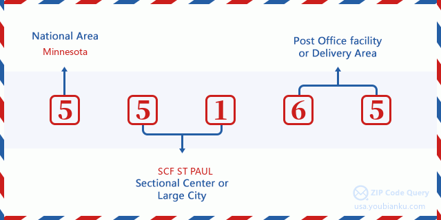
55165 Basic Meaning
What does each digit of ZIP Code 55165 stands for? The first digit designates a national area, which ranges from zero for the Northeast to nine for the far West. The 2-3 digits are the code of a sectional center facility in that region. The last two digits designate small post offices or postal zones.
Online Map

This is online map of the address Saint Paul, Minnesota, United States. You may use button to move and zoom in / out. The map information is for reference only.
Geographic

The latitude of the Zip code 55165 is 44.944500, the longitude is -93.093200, and the elevation is 789. It has land area of 0 square miles, and water area of 0 square miles. The time zone for ZIP code 55165 is Central (GMT -06:00). Daylight saving time should be observed in the area where the zip code is located.
- Latitude: 44.944500
- Longitude: -93.093200
- Elevation: 789
- Land Area: 0
- Water Area: 0
- Time Zone: Central (GMT -06:00)
- Region: Midwest
- Division: West North Central
- Day Light Saving: Y
Congressional District

The Congressional District for ZIP code 55165 is Minnesota's 04th congressional district, the Congressional Land Area is 332.49 square mile.
- Congressional District: 04th
- Congressional Land Area: 332.49
Delivery

In the ZIP code 55165, there are 0 residential delivery mailboxes and centralized units, and 0 commercial delivery mailbox and centralized units, 0 single family deliveries and 0 multifamily deliveries, and the box count is 0. The main post office has city delivery carrier routes for the ZIP code 55165.
- Delivery Residential: 0
- Delivery Business: 0
- Delivery Total: 0
- Single Family Delivery Units: 0
- Multi Family Delivery Units: 0
- City Delivery Indicator: Y


Add new comment