ZIP Code: 55344, Eden Prairie, MN
ZIP Code 55344 is located in Eden Prairie, Minnesota. Its detail State, County, City, Longitude, Latitude, Envelope Example, Population is as below.
ZIP Code 55344 Information

-
-
Country:
U.S. - United States
State:
County FIPS:
27053
County:
City:
Area Code:
City Type ?In many cases, a ZIP Code can have multiple "names", meaning cities, towns, or subdivisions, in its boundaries. However, it will ALWAYS have exactly 1 "default" name. D - Default - This is the "preferred" name - by the USPS - for a city. Each ZIP Code has one - and only one - "default" name. In most cases, this is what people who live in that area call the city as well. A - Acceptable - This name can be used for mailing purposes. Often times alternative names are large neighborhoods or sections of the city/town. In some cases a ZIP Code may have several "acceptable" names which is used to group towns under one ZIP Code. N - Not Acceptable - A "not acceptable" name is, in many cases, a nickname that residents give that location. According to the USPS, you should NOT send mail to that ZIP Code using the "not acceptable" name when mailing.:
D (Default)
ZIP Code:
55344
❓What does D (Default) mean? This is the "preferred" name - by the USPS - for a city. Each ZIP Code has one - and only one - "default" name. In most cases, this is what people who live in that area call the city as well.
-


-
Iconic US Landmark Legacy Designs
Get PNG, SVG, EPS, AI, PDF Versions at Just $0.1
 Download Now
-


ZipCodeCraft
ZIP Code 55344 Plus 4
ZIP Code 5 plus 4 is the extension of 5-digit zip code, It can be used to locate a more detailed location. The last four digits designate segment or one side of a street or an apartment. You can find the ZIP+4 code and corresponding address of the zip code 55344 below.
| ZIP Code 5 Plus 4 | Address |
|---|---|
| 55344-0001 | 8501 FLYING CLOUD DR, EDEN PRAIRIE, MN |
| 55344-0002 | 8501 FLYING CLOUD DR #OFC , EDEN PRAIRIE, MN |
| 55344-0003 | 8501 FLYING CLOUD DR #M101 , EDEN PRAIRIE, MN |
| 55344-0004 | 8501 FLYING CLOUD DR #00000011 , EDEN PRAIRIE, MN |
| 55344-0005 | 8501 FLYING CLOUD DR #00000201 , EDEN PRAIRIE, MN |
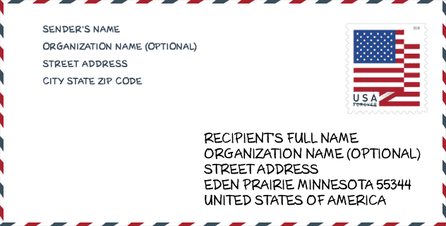
Envelope Example

This is an example of a US zip envelope. You can use a 5-digit zipcode or a detailed 9-digit zipcode to copy the mail in the following address format.
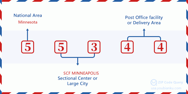
55344 Basic Meaning
What does each digit of ZIP Code 55344 stands for? The first digit designates a national area, which ranges from zero for the Northeast to nine for the far West. The 2-3 digits are the code of a sectional center facility in that region. The last two digits designate small post offices or postal zones.
Online Map

This is online map of the address Eden Prairie, Minnesota, United States. You may use button to move and zoom in / out. The map information is for reference only.
University

This is the ZIP Code 55344 - University page list. Its detail university Name, Street, City, State, ZIP Code, Phone is as below.
| Name | Street | City | State | ZIP Code | Phone |
| Empire Beauty School-Eden Prairie | 964 Prairie Center Dr. | Eden Prairie | MN | 55344 | - |
| ITT Technical Institute-Eden Prairie | 7905 Golden Triangle Drive, Suite 100 | Eden Prairie | MN | 55344 | - |
Museum

This is the ZIP Code 55344 - Museum page list. Its detail Museum Name, Street, City, State, ZIP Code, Phone is as below.
- Name: EDEN PRAIRIE HISTORICAL SOCIETY
- Street: 8080 MITCHELL ROAD
- City: EDEN PRAIRIE
- State: MN
- ZIP Code: 55344
- Phone: (952) 974-4377
Library

This is the ZIP Code 55344 - Library page list. Its detail Library Name, Address, City, State, ZIP Code, Phone is as below.
- Name: EDEN PRAIRIE LIBRARY
- Address: 565 PRAIRIE CENTER DRIVE
- City: EDEN PRAIRIE
- State: MN - Minnesota
- ZIP Code: 55344
- Phone: (612) 543-6275
Population for ZIP Code 55344

What is the total population in ZIP Code 55344? Below is detail information.
- Population for ZIP Code 55344: 14,955
- 2010 Population: 13,952
The 2020 demographic statistics are in progress. The current population in ZIP code 55344 is 14,955, and the population in 2010 is 13,952.
Gender

In all the statistical population, the male population is 6,638, the female population is 7,314.
- Male Population: 6,638
- Female Population: 7,314
Race

In all the statistical population, the male population is 6,638, the female population is 7,314.
- White Population: 9,697
- Black Population: 1,947
- Hispanic Population: 686
- Asian Population: 2,198
- Hawaiian Population: 19
- Indian Population: 139
- Other Population: 409
Age

In all the statistical population, the White population is 9,697, the Black population is 1,947, the Hispanic population is 686, the Asian population is 2,198, the Hawaiian population is 19, the Indian Ppopulation is 139 and Other population is 409.
- Age's Median: 32.3
- Median of male age: 31.6
- Median of female age: 33.1
Households for ZIP Code 55344
ZIP code 55344 has 6,773 households, with an average number of 2.04 persons per household. The average income per household in Zip code 55344 is 69,264 USD, and the average house value is 243,300 USD.
- Households Per Zipcode: 6,773
- Persons Per Household: 2.04
- Average House Value: 243,300
- Income Per Household: 69,264
Geographic

The latitude of the Zip code 55344 is 44.864078, the longitude is -93.441708, and the elevation is 844. It has land area of 8.816 square miles, and water area of 0.708 square miles. The time zone for ZIP code 55344 is Central (GMT -06:00). Daylight saving time should be observed in the area where the zip code is located.
- Latitude: 44.864078
- Longitude: -93.441708
- Elevation: 844
- Land Area: 8.816
- Water Area: 0.708
- Time Zone: Central (GMT -06:00)
- Region: Midwest
- Division: West North Central
- Day Light Saving: Y
Congressional District

The Congressional District for ZIP code 55344 is Minnesota's 3rd congressional district, the Congressional Land Area is 527.05 square mile.
- Congressional District: 3rd
- Congressional Land Area: 527.05
Delivery

In the ZIP code 55344, there are 7,331 residential delivery mailboxes and centralized units, and 1,402 commercial delivery mailbox and centralized units, 698 single family deliveries and 4,834 multifamily deliveries, and the box count is 11,161. The main post office has city delivery carrier routes for the ZIP code 55344.
- Delivery Residential: 7,331
- Delivery Business: 1,402
- Delivery Total: 11,161
- Single Family Delivery Units: 698
- Multi Family Delivery Units: 4,834
- City Delivery Indicator: Y
Business

In ZIP code 55344, the number of business is 1,474, the number of employee is 51,224, the business first quarter payroll is 1,112,928,000 USD, the business annual payroll is 3,970,557,000 USD.
- Number Of Businesses: 1,474
- Number Of Employees: 51,224
- Business First Quarter Payroll: 1,112,928,000
- Business Annual Payroll: 3,970,557,000
Social Security Benefits

There are 2,155 beneficiaries with benefits in current-payment status for ZIP code 55344, of which 1,715 are retired workers, 145 are disabled workers, 120 are widow(er)s and parents, 105 are spouses and 70 are children. The number of beneficiaries aged 65 or older is 1,885. The total monthly benefits are 3,595,000 USD, of which 3,045,000 USD for retired workers, 207,000 USD for widow(er)s and parents.
- Total Number: 2,155
- Retired workers Number: 1,715
- Disabled workers Number: 145
- Widow(er)s and parents Number: 120
- Spouses Number: 105
- Children Number: 70
- All beneficiaries per month: 3,595,000
- Retired workers per month: 3,045,000
- Widow(er)s and parents per month: 207,000
- Number of beneficiaries aged 65 or older: 1,885


Add new comment