United States ZIP Code: 58436
This is the North Dakota ZIP Code 58436 page list. Its detail State, County, City, Longitude, Latitude, Envelope Example, Population is as below.
, featuring the iconic Ellendale Opera House, Coleman Museum, and North Dakota landscape. The image merges cultural heritage with postal elements, such as the vintage airmail envelope portraying the Dickey County Courthouse stamp and '58436' cancellation mark.")
ZIP Code 58436 Information

-
-
Country:
U.S. - United States
State:
State FIPS:
38
Area Code:
ZIP Code:
58436
ZIP Type:
S (Standard)
❓What does S (Standard) mean? A "standard" ZIP Code is what most people think of when they talk about ZIP Codes - essentially a town, city, or a division of a city that has mail service.
ZIP Code 58436 - City

This is the city information corresponding to 58436:
| State | County | City | City Type ?In many cases, a ZIP Code can have multiple "names", meaning cities, towns, or subdivisions, in its boundaries. However, it will ALWAYS have exactly 1 "default" name. D - Default - This is the "preferred" name - by the USPS - for a city. Each ZIP Code has one - and only one - "default" name. In most cases, this is what people who live in that area call the city as well. A - Acceptable - This name can be used for mailing purposes. Often times alternative names are large neighborhoods or sections of the city/town. In some cases a ZIP Code may have several "acceptable" names which is used to group towns under one ZIP Code. N - Not Acceptable - A "not acceptable" name is, in many cases, a nickname that residents give that location. According to the USPS, you should NOT send mail to that ZIP Code using the "not acceptable" name when mailing. | ZIP Code |
|---|---|---|---|---|
| ND | Dickey | Ellendale | D (Default) | 58436 |
| ND | Dickey | Monango | A (Acceptable) | 58436 |
❓What does D (Default) mean? This is the "preferred" name - by the USPS - for a city. Each ZIP Code has one - and only one - "default" name. In most cases, this is what people who live in that area call the city as well.
❓What does A (Acceptable) mean? This name can be used for mailing purposes. Often times alternative names are large neighborhoods or sections of the city/town. In some cases a ZIP Code may have several "acceptable" names which is used to group towns under one ZIP Code.
ZIP Code 58436 Plus 4
ZIP Code 5 plus 4 is the extension of 5-digit zip code, It can be used to locate a more detailed location. The last four digits designate segment or one side of a street or an apartment. You can find the ZIP+4 code and corresponding address of the zip code 58436 below.
| ZIP Code 5 Plus 4 | Address |
|---|---|
| 58436-0001 | PO BOX 1, ELLENDALE, ND |
| 58436-0017 | 58400 HENCENDI ST, ELLENDALE, ND |
| 58436-0021 | PO BOX 21, ELLENDALE, ND |
| 58436-0121 | PO BOX 121, ELLENDALE, ND |
| 58436-0241 | PO BOX 241, ELLENDALE, ND |
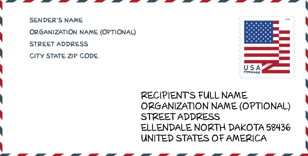
Envelope Example

This is an example of a US zip envelope. You can use a 5-digit zipcode or a detailed 9-digit zipcode to copy the mail in the following address format.
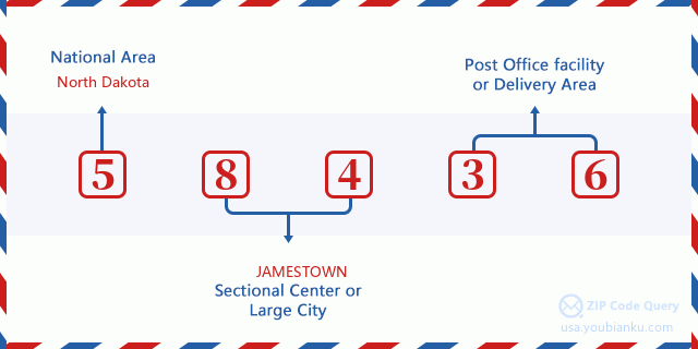
58436 Basic Meaning
What does each digit of ZIP Code 58436 stands for? The first digit designates a national area, which ranges from zero for the Northeast to nine for the far West. The 2-3 digits are the code of a sectional center facility in that region. The last two digits designate small post offices or postal zones.
Online Map

This is online map of the address Monango, North Dakota, United States. You may use button to move and zoom in / out. The map information is for reference only.
Museum

This is the ZIP Code 58436 - Museum page list. Its detail Museum Name, Street, City, State, ZIP Code, Phone is as below.
| Name | Street | City | State | ZIP Code | Phone |
| COTEAU HILLS HISTORICAL CENTER | 1410 1ST ST N | ELLENDALE | ND | 58436 | |
| WHITESTONE HILL BATTLEFIELD HISTORIC SOCIETY | 8692 78TH AVE SE | MONANGO | ND | 58436 | (701) 396-7241 |
Library

This is the ZIP Code 58436 - Library page list. Its detail Library Name, Address, City, State, ZIP Code, Phone is as below.
- Name: ELLENDALE PUBLIC LIBRARY
- Address: 67 1ST AVE SOUTH
- City: ELLENDALE
- State: ND - North Dakota
- ZIP Code: 58436
- Phone: (701) 349-3852
School

This is the ZIP Code 58436 - School page list. Its detail School Name, Address, City, State, ZIP Code is as below.
| School Name | Address | City | State | Grades | ZIP Code |
|---|---|---|---|---|---|
| ELLENDALE ELEMENTARY SCHOOL | 321 1st St N | Ellendale | ND | UG | 58436 |
| ELLENDALE HIGH SCHOOL | 321 1st St N | Ellendale | ND | UG | 58436 |
| ELLENDALE HIGH VIRTUAL ACADEMY | 321 1st ST N | Ellendale | ND | UG | 58436 |
Population for ZIP Code 58436

What is the total population in ZIP Code 58436? Below is detail information.
- Population for ZIP Code 58436: 1,071
- 2010 Population: 1,965
The 2020 demographic statistics are in progress. The current population in ZIP code 58436 is 1,071, and the population in 2010 is 1,965.
Gender

In all the statistical population, the male population is 968, the female population is 997.
- Male Population: 968
- Female Population: 997
Race

In all the statistical population, the male population is 968, the female population is 997.
- White Population: 1,903
- Black Population: 36
- Hispanic Population: 24
- Asian Population: 8
- Hawaiian Population: 1
- Indian Population: 53
- Other Population: 7
Age

In all the statistical population, the White population is 1,903, the Black population is 36, the Hispanic population is 24, the Asian population is 8, the Hawaiian population is 1, the Indian Ppopulation is 53 and Other population is 7.
- Age's Median: 40.7
- Median of male age: 37.3
- Median of female age: 44.3
Households for ZIP Code 58436
ZIP code 58436 has 799 households, with an average number of 2.20 persons per household. The average income per household in Zip code 58436 is 51,023 USD, and the average house value is 94,900 USD.
- Households Per Zipcode: 799
- Persons Per Household: 2.20
- Average House Value: 94,900
- Income Per Household: 51,023
Geographic

The latitude of the Zip code 58436 is 46.109701, the longitude is -98.495294, and the elevation is 1453. It has land area of 317.392 square miles, and water area of 0.576 square miles. The time zone for ZIP code 58436 is Central (GMT -06:00). Daylight saving time should be observed in the area where the zip code is located.
- Latitude: 46.109701
- Longitude: -98.495294
- Elevation: 1453
- Land Area: 317.392
- Water Area: 0.576
- Time Zone: Central (GMT -06:00)
- Region: Midwest
- Division: West North Central
- Day Light Saving: Y
Delivery

In the ZIP code 58436, there are 487 residential delivery mailboxes and centralized units, and 12 commercial delivery mailbox and centralized units, 440 single family deliveries and 47 multifamily deliveries, and the box count is 816. The main post office does not have city delivery carrier routes for the ZIP code 58436.
- Delivery Residential: 487
- Delivery Business: 12
- Delivery Total: 816
- Single Family Delivery Units: 440
- Multi Family Delivery Units: 47
- City Delivery Indicator: N
Business

In ZIP code 58436, the number of business is 74, the number of employee is 625, the business first quarter payroll is 4,847,000 USD, the business annual payroll is 19,007,000 USD.
- Number Of Businesses: 74
- Number Of Employees: 625
- Business First Quarter Payroll: 4,847,000
- Business Annual Payroll: 19,007,000
Social Security Benefits

There are 410 beneficiaries with benefits in current-payment status for ZIP code 58436, of which 325 are retired workers, 30 are disabled workers, 25 are widow(er)s and parents, 20 are spouses and 10 are children. The number of beneficiaries aged 65 or older is 355. The total monthly benefits are 512,000 USD, of which 427,000 USD for retired workers, 31,000 USD for widow(er)s and parents.
- Total Number: 410
- Retired workers Number: 325
- Disabled workers Number: 30
- Widow(er)s and parents Number: 25
- Spouses Number: 20
- Children Number: 10
- All beneficiaries per month: 512,000
- Retired workers per month: 427,000
- Widow(er)s and parents per month: 31,000
- Number of beneficiaries aged 65 or older: 355


Add new comment