ZIP Code: 72211, Little Rock, AR
ZIP Code 72211 is located in Little Rock, Arkansas. Its detail State, County, City, Longitude, Latitude, Envelope Example, Population is as below.
ZIP Code 72211 Information

-
-
Country:
U.S. - United States
State:
County FIPS:
05119
County:
City:
Area Code:
City Type ?In many cases, a ZIP Code can have multiple "names", meaning cities, towns, or subdivisions, in its boundaries. However, it will ALWAYS have exactly 1 "default" name. D - Default - This is the "preferred" name - by the USPS - for a city. Each ZIP Code has one - and only one - "default" name. In most cases, this is what people who live in that area call the city as well. A - Acceptable - This name can be used for mailing purposes. Often times alternative names are large neighborhoods or sections of the city/town. In some cases a ZIP Code may have several "acceptable" names which is used to group towns under one ZIP Code. N - Not Acceptable - A "not acceptable" name is, in many cases, a nickname that residents give that location. According to the USPS, you should NOT send mail to that ZIP Code using the "not acceptable" name when mailing.:
D (Default)
ZIP Code:
72211
❓What does D (Default) mean? This is the "preferred" name - by the USPS - for a city. Each ZIP Code has one - and only one - "default" name. In most cases, this is what people who live in that area call the city as well.
-


-
Iconic US Landmark Legacy Designs
Get PNG, SVG, EPS, AI, PDF Versions at Just $0.1
 Download Now
-


ZipCodeCraft
ZIP Code 72211 Plus 4
ZIP Code 5 plus 4 is the extension of 5-digit zip code, It can be used to locate a more detailed location. The last four digits designate segment or one side of a street or an apartment. You can find the ZIP+4 code and corresponding address of the zip code 72211 below.
| ZIP Code 5 Plus 4 | Address |
|---|---|
| 72211-1600 | 1 CARROLLTON CT, LITTLE ROCK, AR |
| 72211-1601 | 1 HERITAGE CT, LITTLE ROCK, AR |
| 72211-1602 | 1 JOHNNYCAKE LN, LITTLE ROCK, AR |
| 72211-1603 | 2 KINGS CT, LITTLE ROCK, AR |
| 72211-1604 | 1502 GREEN MOUNTAIN DR #00000260 , LITTLE ROCK, AR |
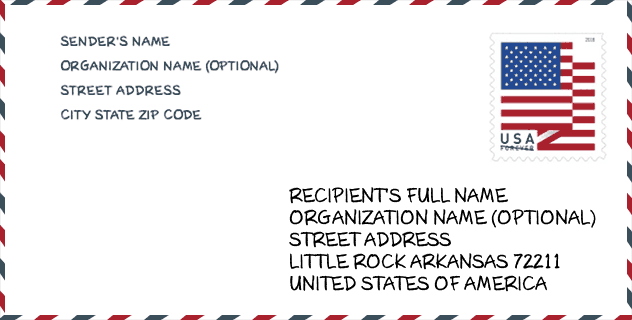
Envelope Example

This is an example of a US zip envelope. You can use a 5-digit zipcode or a detailed 9-digit zipcode to copy the mail in the following address format.
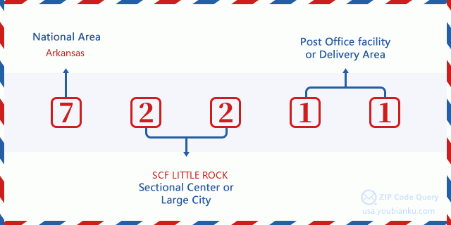
72211 Basic Meaning
What does each digit of ZIP Code 72211 stands for? The first digit designates a national area, which ranges from zero for the Northeast to nine for the far West. The 2-3 digits are the code of a sectional center facility in that region. The last two digits designate small post offices or postal zones.
Online Map

This is online map of the address Little Rock, Arkansas, United States. You may use button to move and zoom in / out. The map information is for reference only.
University

This is the ZIP Code 72211 - University page list. Its detail university Name, Street, City, State, ZIP Code, Phone is as below.
| Name | Street | City | State | ZIP Code | Phone |
| ITT Technical Institute-Little Rock | 12200 Westhaven Drive | Little Rock | AR | 72211 | - |
| Strayer University-Arkansas | 10825 Financial Centre Pkwy Ste 400 | Little Rock | AR | 72211 | (877) 445-7180 |
| University of Phoenix-Arkansas | 10800 Financial Centre Pkwy | Little Rock | AR | 72211 | - |
Hospital

This is the ZIP Code 72211 - Hospital page list. Its detail Hospital Name, Street, City, State, ZIP Code, Phone is as below.
- Name: ARKANSAS HEART HOSPITAL, LLC
- Address: LITTLE ROCK
- City: 1701 S SHACKLEFORD ROAD
- State: AR
- ZIP Code: 72211
- Phone: (501) 219-7000
School
This is the ZIP Code 72211 - School page list. Its detail School Name, Address, City, State, ZIP Code is as below.
| School Name | Address | City | State | Grades | ZIP Code |
|---|---|---|---|---|---|
| Lisa Academy West Elementary School | 12200 WESTHAVEN DR | LITTLE ROCK | AR | KG-05 | 72211 |
| Ark Virtual Academy Middle Sch | 10802 EXECUTIVE CTR DR STE 205 | LITTLE ROCK | AR | 06-08 | 72211 |
| Ark Virtual Academy Elementary | 10802 EXECUTIVE CTR DR STE 205 | LITTLE ROCK | AR | KG-05 | 72211 |
| Terry Elementary School | 10800 MARA LYNN DR | LITTLE ROCK | AR | UG | 72211 |
Population for ZIP Code 72211

What is the total population in ZIP Code 72211? Below is detail information.
- Population for ZIP Code 72211: 25,508
- 2010 Population: 21,288
The 2020 demographic statistics are in progress. The current population in ZIP code 72211 is 25,508, and the population in 2010 is 21,288.
Gender

In all the statistical population, the male population is 9,807, the female population is 11,481.
- Male Population: 9,807
- Female Population: 11,481
Race

In all the statistical population, the male population is 9,807, the female population is 11,481.
- White Population: 14,351
- Black Population: 4,880
- Hispanic Population: 892
- Asian Population: 1,835
- Hawaiian Population: 26
- Indian Population: 163
- Other Population: 426
Age

In all the statistical population, the White population is 14,351, the Black population is 4,880, the Hispanic population is 892, the Asian population is 1,835, the Hawaiian population is 26, the Indian Ppopulation is 163 and Other population is 426.
- Age's Median: 33.7
- Median of male age: 32.8
- Median of female age: 34.7
Households for ZIP Code 72211
ZIP code 72211 has 9,933 households, with an average number of 2.13 persons per household. The average income per household in Zip code 72211 is 61,819 USD, and the average house value is 185,500 USD.
- Households Per Zipcode: 9,933
- Persons Per Household: 2.13
- Average House Value: 185,500
- Income Per Household: 61,819
Geographic

The latitude of the Zip code 72211 is 34.741953, the longitude is -92.417726, and the elevation is 472. It has land area of 7.532 square miles, and water area of 0.059 square miles. The time zone for ZIP code 72211 is Central (GMT -06:00). Daylight saving time should be observed in the area where the zip code is located.
- Latitude: 34.741953
- Longitude: -92.417726
- Elevation: 472
- Land Area: 7.532
- Water Area: 0.059
- Time Zone: Central (GMT -06:00)
- Region: South
- Division: West South Central
- Day Light Saving: Y
Congressional District

The Congressional District for ZIP code 72211 is Arkansas's 2nd congressional district, the Congressional Land Area is 4978.12 square mile.
- Congressional District: 2nd
- Congressional Land Area: 4978.12
Delivery

In the ZIP code 72211, there are 11,976 residential delivery mailboxes and centralized units, and 1,076 commercial delivery mailbox and centralized units, 6,493 single family deliveries and 4,326 multifamily deliveries, and the box count is 14,078. The main post office has city delivery carrier routes for the ZIP code 72211.
- Delivery Residential: 11,976
- Delivery Business: 1,076
- Delivery Total: 14,078
- Single Family Delivery Units: 6,493
- Multi Family Delivery Units: 4,326
- City Delivery Indicator: Y
Business

In ZIP code 72211, the number of business is 1,018, the number of employee is 17,469, the business first quarter payroll is 195,106,000 USD, the business annual payroll is 767,105,000 USD.
- Number Of Businesses: 1,018
- Number Of Employees: 17,469
- Business First Quarter Payroll: 195,106,000
- Business Annual Payroll: 767,105,000
Social Security Benefits

There are 3,530 beneficiaries with benefits in current-payment status for ZIP code 72211, of which 2,640 are retired workers, 400 are disabled workers, 195 are widow(er)s and parents, 95 are spouses and 200 are children. The number of beneficiaries aged 65 or older is 2,785. The total monthly benefits are 5,781,000 USD, of which 4,654,000 USD for retired workers, 325,000 USD for widow(er)s and parents.
- Total Number: 3,530
- Retired workers Number: 2,640
- Disabled workers Number: 400
- Widow(er)s and parents Number: 195
- Spouses Number: 95
- Children Number: 200
- All beneficiaries per month: 5,781,000
- Retired workers per month: 4,654,000
- Widow(er)s and parents per month: 325,000
- Number of beneficiaries aged 65 or older: 2,785


Add new comment