ZIP Code: 78251, San Antonio, TX
ZIP Code 78251 is located in San Antonio, Texas. Its detail State, County, City, Longitude, Latitude, Envelope Example, Population is as below.
ZIP Code 78251 Information

-
-
Country:
U.S. - United States
State:
County FIPS:
48029
County:
City:
Area Code:
City Type ?In many cases, a ZIP Code can have multiple "names", meaning cities, towns, or subdivisions, in its boundaries. However, it will ALWAYS have exactly 1 "default" name. D - Default - This is the "preferred" name - by the USPS - for a city. Each ZIP Code has one - and only one - "default" name. In most cases, this is what people who live in that area call the city as well. A - Acceptable - This name can be used for mailing purposes. Often times alternative names are large neighborhoods or sections of the city/town. In some cases a ZIP Code may have several "acceptable" names which is used to group towns under one ZIP Code. N - Not Acceptable - A "not acceptable" name is, in many cases, a nickname that residents give that location. According to the USPS, you should NOT send mail to that ZIP Code using the "not acceptable" name when mailing.:
D (Default)
ZIP Code:
78251
❓What does D (Default) mean? This is the "preferred" name - by the USPS - for a city. Each ZIP Code has one - and only one - "default" name. In most cases, this is what people who live in that area call the city as well.
ZIP Code 78251 Plus 4
ZIP Code 5 plus 4 is the extension of 5-digit zip code, It can be used to locate a more detailed location. The last four digits designate segment or one side of a street or an apartment. You can find the ZIP+4 code and corresponding address of the zip code 78251 below.
| ZIP Code 5 Plus 4 | Address |
|---|---|
| 78251-1201 | 3900 PIPERS CT, SAN ANTONIO, TX |
| 78251-1202 | 3901 PIPERS CT, SAN ANTONIO, TX |
| 78251-1203 | 7300 PIPERS BLF, SAN ANTONIO, TX |
| 78251-1204 | 7301 PIPERS BLF, SAN ANTONIO, TX |
| 78251-1205 | 7400 PIPERS BLF, SAN ANTONIO, TX |
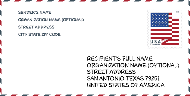
Envelope Example

This is an example of a US zip envelope. You can use a 5-digit zipcode or a detailed 9-digit zipcode to copy the mail in the following address format.
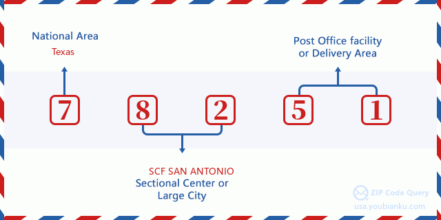
78251 Basic Meaning
What does each digit of ZIP Code 78251 stands for? The first digit designates a national area, which ranges from zero for the Northeast to nine for the far West. The 2-3 digits are the code of a sectional center facility in that region. The last two digits designate small post offices or postal zones.
Online Map

This is online map of the address San Antonio, Texas, United States. You may use button to move and zoom in / out. The map information is for reference only.
University

This is the ZIP Code 78251 - University page list. Its detail university Name, Street, City, State, ZIP Code, Phone is as below.
| Name | Street | City | State | ZIP Code | Phone |
| Northwest Vista College | 3535 N. Ellison Drive | San Antonio | TX | 78251 | (210) 486-4000 |
Museum

This is the ZIP Code 78251 - Museum page list. Its detail Museum Name, Street, City, State, ZIP Code, Phone is as below.
- Name: SECURITY FORCES MUSEUM FOUNDATION
- Street: 2011 FELDTMANN TRAIL
- City: SAN ANTONIO
- State: TX
- ZIP Code: 78251
- Phone:
School
This is the ZIP Code 78251 - School page list. Its detail School Name, Address, City, State, ZIP Code is as below.
| School Name | Address | City | State | Grades | ZIP Code |
|---|---|---|---|---|---|
| HARMONY SCHOOL OF SCIENCE- SAN ANTONIO | 5566 WISEMAN BLVD | SAN ANTONIO | TX | UG | 78251 |
| BASIS SAN ANTONIO - JACK LEWIS JR CAMPUS | 3303 N ELLISON DR | SAN ANTONIO | TX | UG | 78251 |
| BASIS SAN ANTONIO PRI - JACK LEWIS JR CAMPUS | 3303 N ELLISON DR | SAN ANTONIO | TX | UG | 78251 |
| LEWIS EL | 1000 SEASCAPE DR | SAN ANTONIO | TX | UG | 78251 |
| MURNIN EL | 9019 DUGAS | SAN ANTONIO | TX | UG | 78251 |
| VALE MIDDLE | 2120 N ELLISON DR | SAN ANTONIO | TX | UG | 78251 |
Population for ZIP Code 78251

What is the total population in ZIP Code 78251? Below is detail information.
- Population for ZIP Code 78251: 63,252
- 2010 Population: 49,435
The 2020 demographic statistics are in progress. The current population in ZIP code 78251 is 63,252, and the population in 2010 is 49,435.
Gender

In all the statistical population, the male population is 24,078, the female population is 25,357.
- Male Population: 24,078
- Female Population: 25,357
Race

In all the statistical population, the male population is 24,078, the female population is 25,357.
- White Population: 35,801
- Black Population: 5,810
- Hispanic Population: 29,491
- Asian Population: 2,333
- Hawaiian Population: 239
- Indian Population: 740
- Other Population: 6,929
Age

In all the statistical population, the White population is 35,801, the Black population is 5,810, the Hispanic population is 29,491, the Asian population is 2,333, the Hawaiian population is 239, the Indian Ppopulation is 740 and Other population is 6,929.
- Age's Median: 30.3
- Median of male age: 29.4
- Median of female age: 30.9
Households for ZIP Code 78251
ZIP code 78251 has 17,727 households, with an average number of 2.79 persons per household. The average income per household in Zip code 78251 is 65,233 USD, and the average house value is 161,800 USD.
- Households Per Zipcode: 17,727
- Persons Per Household: 2.79
- Average House Value: 161,800
- Income Per Household: 65,233
Geographic

The latitude of the Zip code 78251 is 29.465293, the longitude is -98.669200, and the elevation is 873. It has land area of 15.169 square miles, and water area of 0.03 square miles. The time zone for ZIP code 78251 is Central (GMT -06:00). Daylight saving time should be observed in the area where the zip code is located.
- Latitude: 29.465293
- Longitude: -98.669200
- Elevation: 873
- Land Area: 15.169
- Water Area: 0.03
- Time Zone: Central (GMT -06:00)
- Region: South
- Division: West South Central
- Day Light Saving: Y
Congressional District

The Congressional District for ZIP code 78251 is Texas's 20th|23th congressional district, the Congressional Land Area is 199.68|58059.18 square mile.
- Congressional District: 20th|23th
- Congressional Land Area: 199.68|58059.18
Delivery

In the ZIP code 78251, there are 22,671 residential delivery mailboxes and centralized units, and 1,052 commercial delivery mailbox and centralized units, 3,328 single family deliveries and 9,162 multifamily deliveries, and the box count is 35,235. The main post office has city delivery carrier routes for the ZIP code 78251.
- Delivery Residential: 22,671
- Delivery Business: 1,052
- Delivery Total: 35,235
- Single Family Delivery Units: 3,328
- Multi Family Delivery Units: 9,162
- City Delivery Indicator: Y
Business

In ZIP code 78251, the number of business is 771, the number of employee is 29,885, the business first quarter payroll is 310,254,000 USD, the business annual payroll is 1,176,171,000 USD.
- Number Of Businesses: 771
- Number Of Employees: 29,885
- Business First Quarter Payroll: 310,254,000
- Business Annual Payroll: 1,176,171,000
Social Security Benefits

There are 6,660 beneficiaries with benefits in current-payment status for ZIP code 78251, of which 4,225 are retired workers, 1,100 are disabled workers, 395 are widow(er)s and parents, 255 are spouses and 685 are children. The number of beneficiaries aged 65 or older is 4,490. The total monthly benefits are 8,214,000 USD, of which 5,683,000 USD for retired workers, 485,000 USD for widow(er)s and parents.
- Total Number: 6,660
- Retired workers Number: 4,225
- Disabled workers Number: 1,100
- Widow(er)s and parents Number: 395
- Spouses Number: 255
- Children Number: 685
- All beneficiaries per month: 8,214,000
- Retired workers per month: 5,683,000
- Widow(er)s and parents per month: 485,000
- Number of beneficiaries aged 65 or older: 4,490


Add new comment