ZIP Code: 85546, Safford, AZ
ZIP Code 85546 is located in Safford, Arizona. Its detail State, County, City, Longitude, Latitude, Envelope Example, Population is as below.
ZIP Code 85546 Information

-
-
Country:
U.S. - United States
State:
County FIPS:
04009
County:
City:
Area Code:
City Type ?In many cases, a ZIP Code can have multiple "names", meaning cities, towns, or subdivisions, in its boundaries. However, it will ALWAYS have exactly 1 "default" name. D - Default - This is the "preferred" name - by the USPS - for a city. Each ZIP Code has one - and only one - "default" name. In most cases, this is what people who live in that area call the city as well. A - Acceptable - This name can be used for mailing purposes. Often times alternative names are large neighborhoods or sections of the city/town. In some cases a ZIP Code may have several "acceptable" names which is used to group towns under one ZIP Code. N - Not Acceptable - A "not acceptable" name is, in many cases, a nickname that residents give that location. According to the USPS, you should NOT send mail to that ZIP Code using the "not acceptable" name when mailing.:
D (Default)
ZIP Code:
85546
❓What does D (Default) mean? This is the "preferred" name - by the USPS - for a city. Each ZIP Code has one - and only one - "default" name. In most cases, this is what people who live in that area call the city as well.
ZIP Code 85546 Plus 4
ZIP Code 5 plus 4 is the extension of 5-digit zip code, It can be used to locate a more detailed location. The last four digits designate segment or one side of a street or an apartment. You can find the ZIP+4 code and corresponding address of the zip code 85546 below.
| ZIP Code 5 Plus 4 | Address |
|---|---|
| 85546-0026 | 301 E CHUCKWAGON LOOP, SAFFORD, AZ |
| 85546-1900 | 601 E LONE STAR RD, SAFFORD, AZ |
| 85546-2000 | 501 S GILA AVE, SAFFORD, AZ |
| 85546-2001 | 500 E 4TH ST, SAFFORD, AZ |
| 85546-2002 | 2200 S LADYBUG AVE, SAFFORD, AZ |
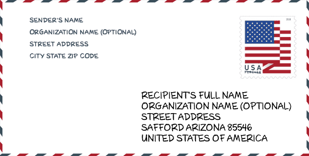
Envelope Example

This is an example of a US zip envelope. You can use a 5-digit zipcode or a detailed 9-digit zipcode to copy the mail in the following address format.
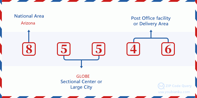
85546 Basic Meaning
What does each digit of ZIP Code 85546 stands for? The first digit designates a national area, which ranges from zero for the Northeast to nine for the far West. The 2-3 digits are the code of a sectional center facility in that region. The last two digits designate small post offices or postal zones.
Online Map

This is online map of the address Safford, Arizona, United States. You may use button to move and zoom in / out. The map information is for reference only.
University

This is the ZIP Code 85546 - University page list. Its detail university Name, Street, City, State, ZIP Code, Phone is as below.
| Name | Street | City | State | ZIP Code | Phone |
| Hair Academy of Safford | 1550 West Thatcher Blvd | Safford | AZ | 85546 | - |
Hospital

This is the ZIP Code 85546 - Hospital page list. Its detail Hospital Name, Street, City, State, ZIP Code, Phone is as below.
- Name: MT. GRAHAM REGIONAL MEDICAL CENTER
- Address: SAFFORD
- City: 1600 SOUTH 20TH AVENUE
- State: AZ
- ZIP Code: 85546
- Phone: (928) 348-4000
Museum

This is the ZIP Code 85546 - Museum page list. Its detail Museum Name, Street, City, State, ZIP Code, Phone is as below.
- Name: MOUNT GRAHAM INTERNATIONAL OBSERVATORY
- Street: 1480 W SWIFT TRAIL
- City: SAFFORD
- State: AZ
- ZIP Code: 85546
- Phone:
Library

This is the ZIP Code 85546 - Library page list. Its detail Library Name, Address, City, State, ZIP Code, Phone is as below.
- Name: SAFFORD CITY-GRAHAM COUNTY LIBRARY
- Address: 808 S 7TH AVE
- City: SAFFORD
- State: AZ - Arizona
- ZIP Code: 85546
- Phone: (928) 432-4165
School
This is the ZIP Code 85546 - School page list. Its detail School Name, Address, City, State, ZIP Code is as below.
- School Name: GIFT - Mt. Graham High School
- Address: 3200 West Discovery Park Blvd.
- City: Safford
- State: AZ
- Grades: 09-12
- ZIP Code: 85546
Population for ZIP Code 85546

What is the total population in ZIP Code 85546? Below is detail information.
- Population for ZIP Code 85546: 17,883
- 2010 Population: 19,677
The 2020 demographic statistics are in progress. The current population in ZIP code 85546 is 17,883, and the population in 2010 is 19,677.
Gender

In all the statistical population, the male population is 10,850, the female population is 8,827.
- Male Population: 10,850
- Female Population: 8,827
Race

In all the statistical population, the male population is 10,850, the female population is 8,827.
- White Population: 16,355
- Black Population: 586
- Hispanic Population: 8,019
- Asian Population: 196
- Hawaiian Population: 56
- Indian Population: 605
- Other Population: 2,558
Age

In all the statistical population, the White population is 16,355, the Black population is 586, the Hispanic population is 8,019, the Asian population is 196, the Hawaiian population is 56, the Indian Ppopulation is 605 and Other population is 2,558.
- Age's Median: 33.6
- Median of male age: 33.5
- Median of female age: 33.8
Households for ZIP Code 85546
ZIP code 85546 has 6,105 households, with an average number of 2.80 persons per household. The average income per household in Zip code 85546 is 52,013 USD, and the average house value is 128,700 USD.
- Households Per Zipcode: 6,105
- Persons Per Household: 2.80
- Average House Value: 128,700
- Income Per Household: 52,013
Geographic

The latitude of the Zip code 85546 is 32.751464, the longitude is -109.446571, and the elevation is 3535. It has land area of 674.757 square miles, and water area of 3.626 square miles. The time zone for ZIP code 85546 is Mountain (GMT -07:00). Daylight saving time should be observed in the area where the zip code is located.
- Latitude: 32.751464
- Longitude: -109.446571
- Elevation: 3535
- Land Area: 674.757
- Water Area: 3.626
- Time Zone: Mountain (GMT -07:00)
- Region: West
- Division: Mountain
- Day Light Saving: N
Congressional District

The Congressional District for ZIP code 85546 is Arizona's 1st congressional district, the Congressional Land Area is 55039.61 square mile.
- Congressional District: 1st
- Congressional Land Area: 55039.61
Delivery

In the ZIP code 85546, there are 6,387 residential delivery mailboxes and centralized units, and 439 commercial delivery mailbox and centralized units, 2,891 single family deliveries and 497 multifamily deliveries, and the box count is 6,795. The main post office has city delivery carrier routes for the ZIP code 85546.
- Delivery Residential: 6,387
- Delivery Business: 439
- Delivery Total: 6,795
- Single Family Delivery Units: 2,891
- Multi Family Delivery Units: 497
- City Delivery Indicator: Y
Business

In ZIP code 85546, the number of business is 334, the number of employee is 4,879, the business first quarter payroll is 49,251,000 USD, the business annual payroll is 194,143,000 USD.
- Number Of Businesses: 334
- Number Of Employees: 4,879
- Business First Quarter Payroll: 49,251,000
- Business Annual Payroll: 194,143,000
Social Security Benefits

There are 3,515 beneficiaries with benefits in current-payment status for ZIP code 85546, of which 2,235 are retired workers, 525 are disabled workers, 280 are widow(er)s and parents, 170 are spouses and 305 are children. The number of beneficiaries aged 65 or older is 2,475. The total monthly benefits are 4,538,000 USD, of which 3,136,000 USD for retired workers, 394,000 USD for widow(er)s and parents.
- Total Number: 3,515
- Retired workers Number: 2,235
- Disabled workers Number: 525
- Widow(er)s and parents Number: 280
- Spouses Number: 170
- Children Number: 305
- All beneficiaries per month: 4,538,000
- Retired workers per month: 3,136,000
- Widow(er)s and parents per month: 394,000
- Number of beneficiaries aged 65 or older: 2,475


Add new comment