ZIP Code: 86442, Bullhead City, AZ
ZIP Code 86442 is located in Bullhead City, Arizona. Its detail State, County, City, Longitude, Latitude, Envelope Example, Population is as below.
ZIP Code 86442 Information

-
-
Country:
U.S. - United States
State:
County FIPS:
04015
County:
City:
Area Code:
City Type ?In many cases, a ZIP Code can have multiple "names", meaning cities, towns, or subdivisions, in its boundaries. However, it will ALWAYS have exactly 1 "default" name. D - Default - This is the "preferred" name - by the USPS - for a city. Each ZIP Code has one - and only one - "default" name. In most cases, this is what people who live in that area call the city as well. A - Acceptable - This name can be used for mailing purposes. Often times alternative names are large neighborhoods or sections of the city/town. In some cases a ZIP Code may have several "acceptable" names which is used to group towns under one ZIP Code. N - Not Acceptable - A "not acceptable" name is, in many cases, a nickname that residents give that location. According to the USPS, you should NOT send mail to that ZIP Code using the "not acceptable" name when mailing.:
D (Default)
ZIP Code:
86442
❓What does D (Default) mean? This is the "preferred" name - by the USPS - for a city. Each ZIP Code has one - and only one - "default" name. In most cases, this is what people who live in that area call the city as well.
-


-
Iconic US Landmark Legacy Designs
Get PNG, SVG, EPS, AI, PDF Versions at Just $0.1
 Download Now
-


ZipCodeCraft
ZIP Code 86442 Plus 4
ZIP Code 5 plus 4 is the extension of 5-digit zip code, It can be used to locate a more detailed location. The last four digits designate segment or one side of a street or an apartment. You can find the ZIP+4 code and corresponding address of the zip code 86442 below.
| ZIP Code 5 Plus 4 | Address |
|---|---|
| 86442-0001 | 5900 MIDERELA DR, BULLHEAD CITY, AZ |
| 86442-3701 | 1801 COOPER RD, BULLHEAD CITY, AZ |
| 86442-3702 | 1627 MOHAVE DR, BULLHEAD CITY, AZ |
| 86442-3703 | 1627 MOHAVE DR #00001101 , BULLHEAD CITY, AZ |
| 86442-3704 | 1627 MOHAVE DR #00001110 , BULLHEAD CITY, AZ |
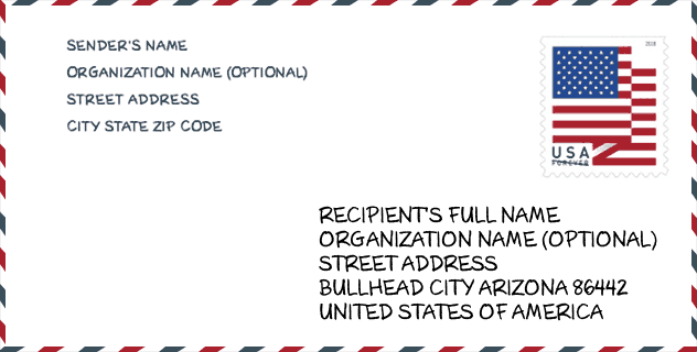
Envelope Example

This is an example of a US zip envelope. You can use a 5-digit zipcode or a detailed 9-digit zipcode to copy the mail in the following address format.
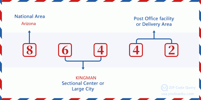
86442 Basic Meaning
What does each digit of ZIP Code 86442 stands for? The first digit designates a national area, which ranges from zero for the Northeast to nine for the far West. The 2-3 digits are the code of a sectional center facility in that region. The last two digits designate small post offices or postal zones.
Online Map

This is online map of the address Bullhead City, Arizona, United States. You may use button to move and zoom in / out. The map information is for reference only.
University

This is the ZIP Code 86442 - University page list. Its detail university Name, Street, City, State, ZIP Code, Phone is as below.
| Name | Street | City | State | ZIP Code | Phone |
| All Beauty College | 2350 Miracle Mile Rd Unit 316 | Bullhead City | AZ | 86442 | (928) 763-3900 |
Hospital

This is the ZIP Code 86442 - Hospital page list. Its detail Hospital Name, Street, City, State, ZIP Code, Phone is as below.
- Name: WESTERN ARIZONA REGIONAL MEDICAL CENTER
- Address: BULLHEAD CITY
- City: 2735 SILVER CREEK ROAD
- State: AZ
- ZIP Code: 86442
- Phone: (928) 763-2273
Museum

This is the ZIP Code 86442 - Museum page list. Its detail Museum Name, Street, City, State, ZIP Code, Phone is as below.
- Name: ARIZONA MILITARY HERITAGE CENTER
- Street: 2245 CLEARWATER DR
- City: BULLHEAD CITY
- State: AZ
- ZIP Code: 86442
- Phone: (928) 758-1088
Library

This is the ZIP Code 86442 - Library page list. Its detail Library Name, Address, City, State, ZIP Code, Phone is as below.
- Name: BULLHEAD CITY BRANCH LIBRARY
- Address: 1170 E HANCOCK RD
- City: BULLHEAD CITY
- State: AZ - Arizona
- ZIP Code: 86442
- Phone: (928) 758-0714
Population for ZIP Code 86442

What is the total population in ZIP Code 86442? Below is detail information.
- Population for ZIP Code 86442: 37,295
- 2010 Population: 33,382
The 2020 demographic statistics are in progress. The current population in ZIP code 86442 is 37,295, and the population in 2010 is 33,382.
Gender

In all the statistical population, the male population is 16,444, the female population is 16,938.
- Male Population: 16,444
- Female Population: 16,938
Race

In all the statistical population, the male population is 16,444, the female population is 16,938.
- White Population: 27,898
- Black Population: 611
- Hispanic Population: 8,533
- Asian Population: 616
- Hawaiian Population: 121
- Indian Population: 687
- Other Population: 4,501
Age

In all the statistical population, the White population is 27,898, the Black population is 611, the Hispanic population is 8,533, the Asian population is 616, the Hawaiian population is 121, the Indian Ppopulation is 687 and Other population is 4,501.
- Age's Median: 47.2
- Median of male age: 46.4
- Median of female age: 47.8
Households for ZIP Code 86442
ZIP code 86442 has 13,880 households, with an average number of 2.39 persons per household. The average income per household in Zip code 86442 is 37,924 USD, and the average house value is 102,500 USD.
- Households Per Zipcode: 13,880
- Persons Per Household: 2.39
- Average House Value: 102,500
- Income Per Household: 37,924
Geographic

The latitude of the Zip code 86442 is 35.084849, the longitude is -114.569897, and the elevation is 885. It has land area of 38.074 square miles, and water area of 0.542 square miles. The time zone for ZIP code 86442 is Mountain (GMT -07:00). Daylight saving time should be observed in the area where the zip code is located.
- Latitude: 35.084849
- Longitude: -114.569897
- Elevation: 885
- Land Area: 38.074
- Water Area: 0.542
- Time Zone: Mountain (GMT -07:00)
- Region: West
- Division: Mountain
- Day Light Saving: N
Congressional District

The Congressional District for ZIP code 86442 is Arizona's 04th congressional district, the Congressional Land Area is 33199.45 square mile.
- Congressional District: 04th
- Congressional Land Area: 33199.45
Delivery

In the ZIP code 86442, there are 15,605 residential delivery mailboxes and centralized units, and 840 commercial delivery mailbox and centralized units, 9,250 single family deliveries and 3,020 multifamily deliveries, and the box count is 16,298. The main post office has city delivery carrier routes for the ZIP code 86442.
- Delivery Residential: 15,605
- Delivery Business: 840
- Delivery Total: 16,298
- Single Family Delivery Units: 9,250
- Multi Family Delivery Units: 3,020
- City Delivery Indicator: Y
Business

In ZIP code 86442, the number of business is 552, the number of employee is 6,077, the business first quarter payroll is 51,078,000 USD, the business annual payroll is 211,024,000 USD.
- Number Of Businesses: 552
- Number Of Employees: 6,077
- Business First Quarter Payroll: 51,078,000
- Business Annual Payroll: 211,024,000
Social Security Benefits

There are 11,190 beneficiaries with benefits in current-payment status for ZIP code 86442, of which 8,260 are retired workers, 1,520 are disabled workers, 720 are widow(er)s and parents, 245 are spouses and 445 are children. The number of beneficiaries aged 65 or older is 8,450. The total monthly benefits are 15,046,000 USD, of which 11,643,000 USD for retired workers, 983,000 USD for widow(er)s and parents.
- Total Number: 11,190
- Retired workers Number: 8,260
- Disabled workers Number: 1,520
- Widow(er)s and parents Number: 720
- Spouses Number: 245
- Children Number: 445
- All beneficiaries per month: 15,046,000
- Retired workers per month: 11,643,000
- Widow(er)s and parents per month: 983,000
- Number of beneficiaries aged 65 or older: 8,450


Add new comment