ZIP Code: 90650, Norwalk, CA
ZIP Code 90650 is located in Norwalk, California. Its detail State, County, City, Longitude, Latitude, Envelope Example, Population is as below.
ZIP Code 90650 Information

-
-
Country:
U.S. - United States
State:
County FIPS:
06037
City:
Area Code:
City Type ?In many cases, a ZIP Code can have multiple "names", meaning cities, towns, or subdivisions, in its boundaries. However, it will ALWAYS have exactly 1 "default" name. D - Default - This is the "preferred" name - by the USPS - for a city. Each ZIP Code has one - and only one - "default" name. In most cases, this is what people who live in that area call the city as well. A - Acceptable - This name can be used for mailing purposes. Often times alternative names are large neighborhoods or sections of the city/town. In some cases a ZIP Code may have several "acceptable" names which is used to group towns under one ZIP Code. N - Not Acceptable - A "not acceptable" name is, in many cases, a nickname that residents give that location. According to the USPS, you should NOT send mail to that ZIP Code using the "not acceptable" name when mailing.:
D (Default)
ZIP Code:
90650
❓What does D (Default) mean? This is the "preferred" name - by the USPS - for a city. Each ZIP Code has one - and only one - "default" name. In most cases, this is what people who live in that area call the city as well.
ZIP Code 90650 Plus 4
ZIP Code 5 plus 4 is the extension of 5-digit zip code, It can be used to locate a more detailed location. The last four digits designate segment or one side of a street or an apartment. You can find the ZIP+4 code and corresponding address of the zip code 90650 below.
| ZIP Code 5 Plus 4 | Address |
|---|---|
| 90650-0100 | 11101 IMPERIAL HWY #00000099 , NORWALK, CA |
| 90650-0101 | 11101 IMPERIAL HWY #00000100 , NORWALK, CA |
| 90650-0102 | 11101 IMPERIAL HWY #00000101 , NORWALK, CA |
| 90650-0103 | 11101 IMPERIAL HWY #00000102 , NORWALK, CA |
| 90650-0104 | 11101 IMPERIAL HWY #00000103 , NORWALK, CA |
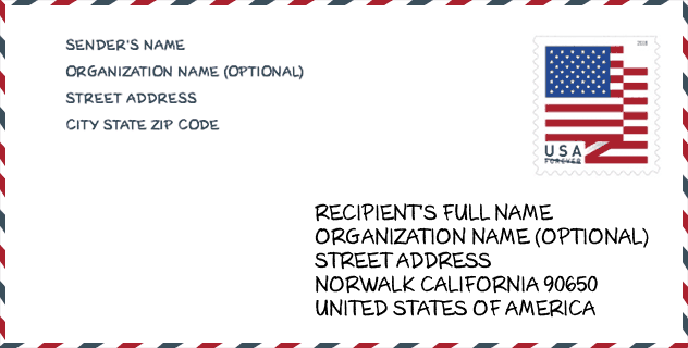
Envelope Example

This is an example of a US zip envelope. You can use a 5-digit zipcode or a detailed 9-digit zipcode to copy the mail in the following address format.
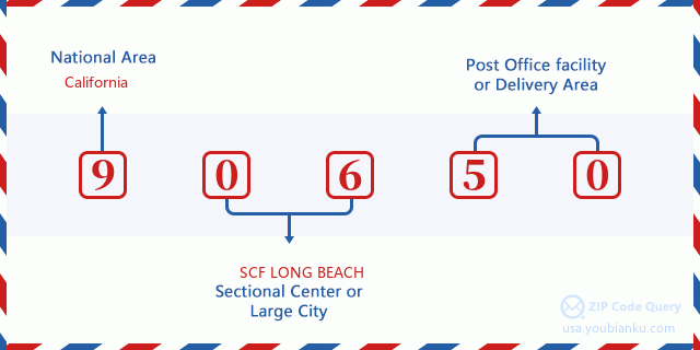
90650 Basic Meaning
What does each digit of ZIP Code 90650 stands for? The first digit designates a national area, which ranges from zero for the Northeast to nine for the far West. The 2-3 digits are the code of a sectional center facility in that region. The last two digits designate small post offices or postal zones.
Online Map

This is online map of the address Norwalk, California, United States. You may use button to move and zoom in / out. The map information is for reference only.
University

This is the ZIP Code 90650 - University page list. Its detail university Name, Street, City, State, ZIP Code, Phone is as below.
| Name | Street | City | State | ZIP Code | Phone |
| ATI College-Norwalk | 12440 Firestone Blvd Ste 2001 | Norwalk | CA | 90650 | - |
Hospital

This is the ZIP Code 90650 - Hospital page list. Its detail Hospital Name, Street, City, State, ZIP Code, Phone is as below.
| Name | Address | City | State | ZIP Code | Phone |
|---|---|---|---|---|---|
| COAST PLAZA HOSPITAL | 13100 STUDERBAKER ROAD | NORWALK | CA | 90650 | (310) 356-0550 |
| DEPT OF STATE HOSPITALS - METROPOLITAN - PSY | 11401 S NORWALK BLVD | NORWALK | CA | 90650 | (562) 863-7011 |
Museum

This is the ZIP Code 90650 - Museum page list. Its detail Museum Name, Street, City, State, ZIP Code, Phone is as below.
| Name | Street | City | State | ZIP Code | Phone |
| SPROUL MUSEUM | 12237 SPROUL ST | NORWALK | CA | 90650 | (562) 929-5625 |
| HARGITT HOUSE | 12426 MAPLEDALE ST | NORWALK | CA | 90650 | (562) 864-9663 |
| CERRITOS COLLEGE ART GALLERY | 11110 ALONDRA BLVD | NORWALK | CA | 90650 | (562) 860-2451 |
Library

This is the ZIP Code 90650 - Library page list. Its detail Library Name, Address, City, State, ZIP Code, Phone is as below.
| Name | Address | City | State | ZIP Code | Phone |
|---|---|---|---|---|---|
| ALONDRA LIBRARY | 11949 ALONDRA BLVD. | NORWALK | CA | 90650 | (562) 868-7771 |
| NORWALK LIBRARY | 12350 IMPERIAL HWY. | NORWALK | CA | 90650 | (562) 868-0775 |
Population for ZIP Code 90650

What is the total population in ZIP Code 90650? Below is detail information.
- Population for ZIP Code 90650: 105,179
- 2010 Population: 105,549
The 2020 demographic statistics are in progress. The current population in ZIP code 90650 is 105,179, and the population in 2010 is 105,549.
Gender

In all the statistical population, the male population is 52,364, the female population is 53,185.
- Male Population: 52,364
- Female Population: 53,185
Race

In all the statistical population, the male population is 52,364, the female population is 53,185.
- White Population: 55,720
- Black Population: 5,240
- Hispanic Population: 74,041
- Asian Population: 13,787
- Hawaiian Population: 752
- Indian Population: 1,916
- Other Population: 32,974
Age

In all the statistical population, the White population is 55,720, the Black population is 5,240, the Hispanic population is 74,041, the Asian population is 13,787, the Hawaiian population is 752, the Indian Ppopulation is 1,916 and Other population is 32,974.
- Age's Median: 32.5
- Median of male age: 31.0
- Median of female age: 34.1
Households for ZIP Code 90650
ZIP code 90650 has 27,130 households, with an average number of 3.83 persons per household. The average income per household in Zip code 90650 is 66,453 USD, and the average house value is 410,400 USD.
- Households Per Zipcode: 27,130
- Persons Per Household: 3.83
- Average House Value: 410,400
- Income Per Household: 66,453
Geographic

The latitude of the Zip code 90650 is 33.907250, the longitude is -118.075758, and the elevation is 97. It has land area of 9.81 square miles, and water area of 0.039 square miles. The time zone for ZIP code 90650 is Pacific (GMT -08:00). Daylight saving time should be observed in the area where the zip code is located.
- Latitude: 33.907250
- Longitude: -118.075758
- Elevation: 97
- Land Area: 9.81
- Water Area: 0.039
- Time Zone: Pacific (GMT -08:00)
- Region: West
- Division: Pacific
- Day Light Saving: Y
Congressional District

The Congressional District for ZIP code 90650 is California's 38th congressional district, the Congressional Land Area is 101.46 square mile.
- Congressional District: 38th
- Congressional Land Area: 101.46
Delivery

In the ZIP code 90650, there are 27,462 residential delivery mailboxes and centralized units, and 1,584 commercial delivery mailbox and centralized units, 20,818 single family deliveries and 5,005 multifamily deliveries, and the box count is 30,126. The main post office has city delivery carrier routes for the ZIP code 90650.
- Delivery Residential: 27,462
- Delivery Business: 1,584
- Delivery Total: 30,126
- Single Family Delivery Units: 20,818
- Multi Family Delivery Units: 5,005
- City Delivery Indicator: Y
Business

In ZIP code 90650, the number of business is 1,110, the number of employee is 18,099, the business first quarter payroll is 233,363,000 USD, the business annual payroll is 937,101,000 USD.
- Number Of Businesses: 1,110
- Number Of Employees: 18,099
- Business First Quarter Payroll: 233,363,000
- Business Annual Payroll: 937,101,000
Social Security Benefits

There are 14,345 beneficiaries with benefits in current-payment status for ZIP code 90650, of which 10,000 are retired workers, 1,500 are disabled workers, 1,040 are widow(er)s and parents, 1,015 are spouses and 790 are children. The number of beneficiaries aged 65 or older is 11,200. The total monthly benefits are 17,371,000 USD, of which 12,925,000 USD for retired workers, 1,303,000 USD for widow(er)s and parents.
- Total Number: 14,345
- Retired workers Number: 10,000
- Disabled workers Number: 1,500
- Widow(er)s and parents Number: 1,040
- Spouses Number: 1,015
- Children Number: 790
- All beneficiaries per month: 17,371,000
- Retired workers per month: 12,925,000
- Widow(er)s and parents per month: 1,303,000
- Number of beneficiaries aged 65 or older: 11,200


Add new comment