ZIP Code: 92071, Santee, CA
ZIP Code 92071 is located in Santee, California. Its detail State, County, City, Longitude, Latitude, Envelope Example, Population is as below.
ZIP Code 92071 Information

-
-
Country:
U.S. - United States
State:
County FIPS:
06073
City:
Area Code:
City Type ?In many cases, a ZIP Code can have multiple "names", meaning cities, towns, or subdivisions, in its boundaries. However, it will ALWAYS have exactly 1 "default" name. D - Default - This is the "preferred" name - by the USPS - for a city. Each ZIP Code has one - and only one - "default" name. In most cases, this is what people who live in that area call the city as well. A - Acceptable - This name can be used for mailing purposes. Often times alternative names are large neighborhoods or sections of the city/town. In some cases a ZIP Code may have several "acceptable" names which is used to group towns under one ZIP Code. N - Not Acceptable - A "not acceptable" name is, in many cases, a nickname that residents give that location. According to the USPS, you should NOT send mail to that ZIP Code using the "not acceptable" name when mailing.:
D (Default)
ZIP Code:
92071
❓What does D (Default) mean? This is the "preferred" name - by the USPS - for a city. Each ZIP Code has one - and only one - "default" name. In most cases, this is what people who live in that area call the city as well.
ZIP Code 92071 Plus 4
ZIP Code 5 plus 4 is the extension of 5-digit zip code, It can be used to locate a more detailed location. The last four digits designate segment or one side of a street or an apartment. You can find the ZIP+4 code and corresponding address of the zip code 92071 below.
| ZIP Code 5 Plus 4 | Address |
|---|---|
| 92071-1001 | 10300 CADWELL RD, SANTEE, CA |
| 92071-1002 | 10301 CADWELL RD, SANTEE, CA |
| 92071-1003 | 10100 CARRIE ELLEN CT, SANTEE, CA |
| 92071-1004 | 10101 CARRIE ELLEN CT, SANTEE, CA |
| 92071-1005 | 9200 DALEHURST RD, SANTEE, CA |
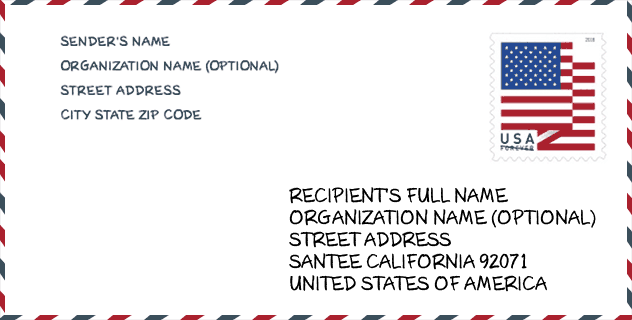
Envelope Example

This is an example of a US zip envelope. You can use a 5-digit zipcode or a detailed 9-digit zipcode to copy the mail in the following address format.
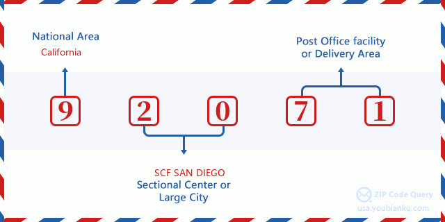
92071 Basic Meaning
What does each digit of ZIP Code 92071 stands for? The first digit designates a national area, which ranges from zero for the Northeast to nine for the far West. The 2-3 digits are the code of a sectional center facility in that region. The last two digits designate small post offices or postal zones.
Online Map

This is online map of the address Santee, California, United States. You may use button to move and zoom in / out. The map information is for reference only.
University

This is the ZIP Code 92071 - University page list. Its detail university Name, Street, City, State, ZIP Code, Phone is as below.
| Name | Street | City | State | ZIP Code | Phone |
| San Diego Christian College | 200 Riverview Parkway | Santee | CA | 92071 | - |
| San Diego Christian College | 200 Riverview Parkway | Santee | CA | 92071 | (619) 201-8700 |
Library

This is the ZIP Code 92071 - Library page list. Its detail Library Name, Address, City, State, ZIP Code, Phone is as below.
- Name: SANTEE LIBRARY
- Address: 9225 CARLTON HILLS BLVD. #17
- City: SANTEE
- State: CA - California
- ZIP Code: 92071
- Phone: (619) 448-1863
School
This is the ZIP Code 92071 - School page list. Its detail School Name, Address, City, State, ZIP Code is as below.
- School Name: Santee Alternative
- Address: 10250 El Nopal
- City: Santee
- State: CA
- Grades: UG
- ZIP Code: 92071
Population for ZIP Code 92071

What is the total population in ZIP Code 92071? Below is detail information.
- Population for ZIP Code 92071: 55,137
- 2010 Population: 53,422
The 2020 demographic statistics are in progress. The current population in ZIP code 92071 is 55,137, and the population in 2010 is 53,422.
Gender

In all the statistical population, the male population is 25,826, the female population is 27,596.
- Male Population: 25,826
- Female Population: 27,596
Race

In all the statistical population, the male population is 25,826, the female population is 27,596.
- White Population: 46,690
- Black Population: 1,620
- Hispanic Population: 8,700
- Asian Population: 3,252
- Hawaiian Population: 635
- Indian Population: 1,000
- Other Population: 3,398
Age

In all the statistical population, the White population is 46,690, the Black population is 1,620, the Hispanic population is 8,700, the Asian population is 3,252, the Hawaiian population is 635, the Indian Ppopulation is 1,000 and Other population is 3,398.
- Age's Median: 37.2
- Median of male age: 35.7
- Median of female age: 38.6
Households for ZIP Code 92071
ZIP code 92071 has 19,310 households, with an average number of 2.72 persons per household. The average income per household in Zip code 92071 is 83,712 USD, and the average house value is 422,600 USD.
- Households Per Zipcode: 19,310
- Persons Per Household: 2.72
- Average House Value: 422,600
- Income Per Household: 83,712
Geographic

The latitude of the Zip code 92071 is 32.869887, the longitude is -117.013039, and the elevation is 586. It has land area of 17.582 square miles, and water area of 0.191 square miles. The time zone for ZIP code 92071 is Pacific (GMT -08:00). Daylight saving time should be observed in the area where the zip code is located.
- Latitude: 32.869887
- Longitude: -117.013039
- Elevation: 586
- Land Area: 17.582
- Water Area: 0.191
- Time Zone: Pacific (GMT -08:00)
- Region: West
- Division: Pacific
- Day Light Saving: Y
Congressional District

The Congressional District for ZIP code 92071 is California's 50th|53th congressional district, the Congressional Land Area is 2787.35|135.43 square mile.
- Congressional District: 50th|53th
- Congressional Land Area: 2787.35|135.43
Delivery

In the ZIP code 92071, there are 20,271 residential delivery mailboxes and centralized units, and 1,285 commercial delivery mailbox and centralized units, 10,901 single family deliveries and 1,959 multifamily deliveries, and the box count is 20,860. The main post office has city delivery carrier routes for the ZIP code 92071.
- Delivery Residential: 20,271
- Delivery Business: 1,285
- Delivery Total: 20,860
- Single Family Delivery Units: 10,901
- Multi Family Delivery Units: 1,959
- City Delivery Indicator: Y
Business

In ZIP code 92071, the number of business is 1,191, the number of employee is 14,308, the business first quarter payroll is 133,805,000 USD, the business annual payroll is 561,012,000 USD.
- Number Of Businesses: 1,191
- Number Of Employees: 14,308
- Business First Quarter Payroll: 133,805,000
- Business Annual Payroll: 561,012,000
Social Security Benefits

There are 9,585 beneficiaries with benefits in current-payment status for ZIP code 92071, of which 7,215 are retired workers, 1,000 are disabled workers, 595 are widow(er)s and parents, 350 are spouses and 425 are children. The number of beneficiaries aged 65 or older is 7,700. The total monthly benefits are 13,781,000 USD, of which 10,918,000 USD for retired workers, 850,000 USD for widow(er)s and parents.
- Total Number: 9,585
- Retired workers Number: 7,215
- Disabled workers Number: 1,000
- Widow(er)s and parents Number: 595
- Spouses Number: 350
- Children Number: 425
- All beneficiaries per month: 13,781,000
- Retired workers per month: 10,918,000
- Widow(er)s and parents per month: 850,000
- Number of beneficiaries aged 65 or older: 7,700


Add new comment