United States ZIP Code: 92555
This is the California ZIP Code 92555 page list. Its detail State, County, City, Longitude, Latitude, Envelope Example, Population is as below.

ZIP Code 92555 Information

-
-
Country:
U.S. - United States
State:
State FIPS:
06
Area Code:
ZIP Code:
92555
ZIP Type:
S (Standard)
❓What does S (Standard) mean? A "standard" ZIP Code is what most people think of when they talk about ZIP Codes - essentially a town, city, or a division of a city that has mail service.
ZIP Code 92555 - City

This is the city information corresponding to 92555:
| State | County | City | City Type ?In many cases, a ZIP Code can have multiple "names", meaning cities, towns, or subdivisions, in its boundaries. However, it will ALWAYS have exactly 1 "default" name. D - Default - This is the "preferred" name - by the USPS - for a city. Each ZIP Code has one - and only one - "default" name. In most cases, this is what people who live in that area call the city as well. A - Acceptable - This name can be used for mailing purposes. Often times alternative names are large neighborhoods or sections of the city/town. In some cases a ZIP Code may have several "acceptable" names which is used to group towns under one ZIP Code. N - Not Acceptable - A "not acceptable" name is, in many cases, a nickname that residents give that location. According to the USPS, you should NOT send mail to that ZIP Code using the "not acceptable" name when mailing. | ZIP Code |
|---|---|---|---|---|
| CA | Riverside | Moreno Valley | D (Default) | 92555 |
| CA | Riverside | Rancho Belago | A (Acceptable) | 92555 |
❓What does D (Default) mean? This is the "preferred" name - by the USPS - for a city. Each ZIP Code has one - and only one - "default" name. In most cases, this is what people who live in that area call the city as well.
❓What does A (Acceptable) mean? This name can be used for mailing purposes. Often times alternative names are large neighborhoods or sections of the city/town. In some cases a ZIP Code may have several "acceptable" names which is used to group towns under one ZIP Code.
ZIP Code 92555 Plus 4
ZIP Code 5 plus 4 is the extension of 5-digit zip code, It can be used to locate a more detailed location. The last four digits designate segment or one side of a street or an apartment. You can find the ZIP+4 code and corresponding address of the zip code 92555 below.
| ZIP Code 5 Plus 4 | Address |
|---|---|
| 92555-0101 | 1 TERRY FOX, MORENO VALLEY, CA |
| 92555-0777 | PO BOX 0, MORENO VALLEY, CA |
| 92555-1400 | 11400 MAR EL ST, MORENO VALLEY, CA |
| 92555-1401 | 26200 EARLEY WAY, MORENO VALLEY, CA |
| 92555-1402 | 11300 MAR EL ST, MORENO VALLEY, CA |
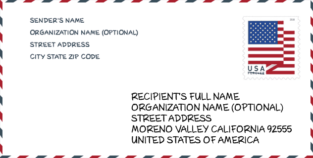
Envelope Example

This is an example of a US zip envelope. You can use a 5-digit zipcode or a detailed 9-digit zipcode to copy the mail in the following address format.
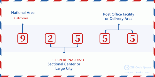
92555 Basic Meaning
What does each digit of ZIP Code 92555 stands for? The first digit designates a national area, which ranges from zero for the Northeast to nine for the far West. The 2-3 digits are the code of a sectional center facility in that region. The last two digits designate small post offices or postal zones.
Online Map

This is online map of the address Rancho Belago, California, United States. You may use button to move and zoom in / out. The map information is for reference only.
Hospital

This is the ZIP Code 92555 - Hospital page list. Its detail Hospital Name, Street, City, State, ZIP Code, Phone is as below.
| Name | Address | City | State | ZIP Code | Phone |
|---|---|---|---|---|---|
| KAISER FOUNDATION HOSPITAL-MORENO VALLEY | 27300 IRIS AVENUE | MORENO VALLEY | CA | 92555 | (951) 251-6000 |
| RIVERSIDE UNIVERSITY HEALTH SYSTEM-MEDICAL CENTER | 26520 CACTUS AVENUE | MORENO VALLEY | CA | 92555 | (951) 486-4000 |
School

This is the ZIP Code 92555 - School page list. Its detail School Name, Address, City, State, ZIP Code is as below.
- School Name: Lasselle Elementary
- Address: 26446 Krameria Ave.
- City: Moreno Valley
- State: CA
- Grades: UG
- ZIP Code: 92555
Population for ZIP Code 92555

What is the total population in ZIP Code 92555? Below is detail information.
- Population for ZIP Code 92555: 41,385
- 2010 Population: 39,076
The 2020 demographic statistics are in progress. The current population in ZIP code 92555 is 41,385, and the population in 2010 is 39,076.
Gender

In all the statistical population, the male population is 19,025, the female population is 20,051.
- Male Population: 19,025
- Female Population: 20,051
Race

In all the statistical population, the male population is 19,025, the female population is 20,051.
- White Population: 18,162
- Black Population: 8,774
- Hispanic Population: 17,048
- Asian Population: 4,583
- Hawaiian Population: 357
- Indian Population: 666
- Other Population: 9,010
Age

In all the statistical population, the White population is 18,162, the Black population is 8,774, the Hispanic population is 17,048, the Asian population is 4,583, the Hawaiian population is 357, the Indian Ppopulation is 666 and Other population is 9,010.
- Age's Median: 30.6
- Median of male age: 29.3
- Median of female age: 31.9
Households for ZIP Code 92555
ZIP code 92555 has 10,798 households, with an average number of 3.61 persons per household. The average income per household in Zip code 92555 is 84,612 USD, and the average house value is 338,300 USD.
- Households Per Zipcode: 10,798
- Persons Per Household: 3.61
- Average House Value: 338,300
- Income Per Household: 84,612
Geographic

The latitude of the Zip code 92555 is 33.901688, the longitude is -117.107273, and the elevation is 1473. It has land area of 80.684 square miles, and water area of 3.103 square miles. The time zone for ZIP code 92555 is Pacific (GMT -08:00). Daylight saving time should be observed in the area where the zip code is located.
- Latitude: 33.901688
- Longitude: -117.107273
- Elevation: 1473
- Land Area: 80.684
- Water Area: 3.103
- Time Zone: Pacific (GMT -08:00)
- Region: West
- Division: Pacific
- Day Light Saving: Y
Congressional District

The Congressional District for ZIP code 92555 is California's 41th|42th congressional district, the Congressional Land Area is 316.54|935.96 square mile.
- Congressional District: 41th|42th
- Congressional Land Area: 316.54|935.96
Delivery

In the ZIP code 92555, there are 11,464 residential delivery mailboxes and centralized units, and 156 commercial delivery mailbox and centralized units, 2,699 single family deliveries and 666 multifamily deliveries, and the box count is 11,519. The main post office has city delivery carrier routes for the ZIP code 92555.
- Delivery Residential: 11,464
- Delivery Business: 156
- Delivery Total: 11,519
- Single Family Delivery Units: 2,699
- Multi Family Delivery Units: 666
- City Delivery Indicator: Y
Business

In ZIP code 92555, the number of business is 303, the number of employee is 7,669, the business first quarter payroll is 114,555,000 USD, the business annual payroll is 452,318,000 USD.
- Number Of Businesses: 303
- Number Of Employees: 7,669
- Business First Quarter Payroll: 114,555,000
- Business Annual Payroll: 452,318,000
Social Security Benefits

There are 5,500 beneficiaries with benefits in current-payment status for ZIP code 92555, of which 3,770 are retired workers, 615 are disabled workers, 325 are widow(er)s and parents, 300 are spouses and 490 are children. The number of beneficiaries aged 65 or older is 3,945. The total monthly benefits are 6,984,000 USD, of which 5,179,000 USD for retired workers, 412,000 USD for widow(er)s and parents.
- Total Number: 5,500
- Retired workers Number: 3,770
- Disabled workers Number: 615
- Widow(er)s and parents Number: 325
- Spouses Number: 300
- Children Number: 490
- All beneficiaries per month: 6,984,000
- Retired workers per month: 5,179,000
- Widow(er)s and parents per month: 412,000
- Number of beneficiaries aged 65 or older: 3,945


Add new comment