United States ZIP Code: 95715
This is the California ZIP Code 95715 page list. Its detail State, County, City, Longitude, Latitude, Envelope Example, Population is as below.

ZIP Code 95715 Information

-
-
Country:
U.S. - United States
State:
State FIPS:
06
Area Code:
ZIP Code:
95715
ZIP Type:
P (PO Box Only)
❓What does P (PO Box Only) mean? Rural towns, groups of towns, or even high-growth areas of cities are given a "PO Box Only" ZIP Code type.
ZIP Code 95715 - City

This is the city information corresponding to 95715:
| State | County | City | City Type ?In many cases, a ZIP Code can have multiple "names", meaning cities, towns, or subdivisions, in its boundaries. However, it will ALWAYS have exactly 1 "default" name. D - Default - This is the "preferred" name - by the USPS - for a city. Each ZIP Code has one - and only one - "default" name. In most cases, this is what people who live in that area call the city as well. A - Acceptable - This name can be used for mailing purposes. Often times alternative names are large neighborhoods or sections of the city/town. In some cases a ZIP Code may have several "acceptable" names which is used to group towns under one ZIP Code. N - Not Acceptable - A "not acceptable" name is, in many cases, a nickname that residents give that location. According to the USPS, you should NOT send mail to that ZIP Code using the "not acceptable" name when mailing. | ZIP Code |
|---|---|---|---|---|
| CA | Placer | Alta | A (Acceptable) | 95715 |
| CA | Placer | Blue Canyon | N (Not Acceptable) | 95715 |
| CA | Placer | Emigrant Gap | D (Default) | 95715 |
❓What does D (Default) mean? This is the "preferred" name - by the USPS - for a city. Each ZIP Code has one - and only one - "default" name. In most cases, this is what people who live in that area call the city as well.
❓What does A (Acceptable) mean? This name can be used for mailing purposes. Often times alternative names are large neighborhoods or sections of the city/town. In some cases a ZIP Code may have several "acceptable" names which is used to group towns under one ZIP Code.
❓What does N (Not Acceptable) mean? A "not acceptable" name is, in many cases, a nickname that residents give that location. According to the USPS, you should NOT send mail to that ZIP Code using the "not acceptable" name when mailing.
ZIP Code 95715 Plus 4
ZIP Code 5 plus 4 is the extension of 5-digit zip code, It can be used to locate a more detailed location. The last four digits designate segment or one side of a street or an apartment. You can find the ZIP+4 code and corresponding address of the zip code 95715 below.
| ZIP Code 5 Plus 4 | Address |
|---|---|
| 95715-0001 | PO BOX 1, EMIGRANT GAP, CA |
| 95715-0121 | PO BOX 121, EMIGRANT GAP, CA |
| 95715-9998 | 41965 NYACK RD, EMIGRANT GAP, CA |
| 95715-9999 | 0 GENERAL DELIVERY, EMIGRANT GAP, CA |
| 95715-2500 | 41900 NYACK RD, EMIGRANT GAP, CA |
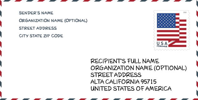
Envelope Example

This is an example of a US zip envelope. You can use a 5-digit zipcode or a detailed 9-digit zipcode to copy the mail in the following address format.
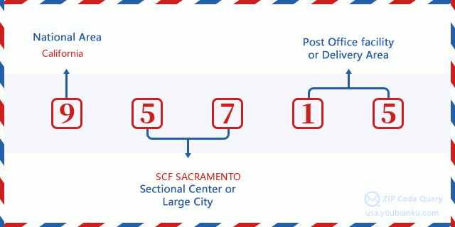
95715 Basic Meaning
What does each digit of ZIP Code 95715 stands for? The first digit designates a national area, which ranges from zero for the Northeast to nine for the far West. The 2-3 digits are the code of a sectional center facility in that region. The last two digits designate small post offices or postal zones.
Online Map

This is online map of the address Emigrant Gap, California, United States. You may use button to move and zoom in / out. The map information is for reference only.
Gender

In all the statistical population, the male population is 65, the female population is 50.
- Male Population: 65
- Female Population: 50
Race

In all the statistical population, the male population is 65, the female population is 50.
- White Population: 109
- Black Population: 0
- Hispanic Population: 5
- Asian Population: 1
- Hawaiian Population: 0
- Indian Population: 16
- Other Population: 2
Age

In all the statistical population, the White population is 109, the Black population is 0, the Hispanic population is 5, the Asian population is 1, the Hawaiian population is 0, the Indian Ppopulation is 16 and Other population is 2.
- Age's Median: 47.4
- Median of male age: 47.8
- Median of female age: 46.0
Households for ZIP Code 95715
ZIP code 95715 has 52 households, with an average number of 2.21 persons per household. The average income per household in Zip code 95715 is 50,250 USD, and the average house value is 191,700 USD.
- Households Per Zipcode: 52
- Persons Per Household: 2.21
- Average House Value: 191,700
- Income Per Household: 50,250
Housing Unit

In ZIP code 95715, the growth rank of housing unit is 91, the number of housing unit was 348,432 in 2010 and increased to 357,138 in 2011, the growth increase number is 8,706, the growth increase percentage is 2.5%.
- Growth Rank: 91
- Housing Units Estimate in 2010: 348,432
- Housing Units Estimate in 2011: 357,138
- Growth Increase Number: 8,706
- Growth Increase Percentage: 2.5%
Geographic

The latitude of the Zip code 95715 is 39.246991, the longitude is -120.645382, and the elevation is 4975. It has land area of 26.056 square miles, and water area of 1.078 square miles. The time zone for ZIP code 95715 is Pacific (GMT -08:00). Daylight saving time should be observed in the area where the zip code is located.
- Latitude: 39.246991
- Longitude: -120.645382
- Elevation: 4975
- Land Area: 26.056
- Water Area: 1.078
- Time Zone: Pacific (GMT -08:00)
- Region: West
- Division: Pacific
- Day Light Saving: Y
Congressional District

The Congressional District for ZIP code 95715 is California's 1st congressional district, the Congressional Land Area is 28089.47 square mile.
- Congressional District: 1st
- Congressional Land Area: 28089.47
Delivery

In the ZIP code 95715, there are 0 residential delivery mailboxes and centralized units, and 0 commercial delivery mailbox and centralized units, 0 single family deliveries and 0 multifamily deliveries, and the box count is 49. The main post office does not have city delivery carrier routes for the ZIP code 95715.
- Delivery Residential: 0
- Delivery Business: 0
- Delivery Total: 49
- Single Family Delivery Units: 0
- Multi Family Delivery Units: 0
- City Delivery Indicator: N
Business

In ZIP code 95715, the number of business is 5, the number of employee is 32, the business first quarter payroll is 248,000 USD, the business annual payroll is 1,136,000 USD.
- Number Of Businesses: 5
- Number Of Employees: 32
- Business First Quarter Payroll: 248,000
- Business Annual Payroll: 1,136,000
Social Security Benefits

There are 20 beneficiaries with benefits in current-payment status for ZIP code 95715, of which 15 are retired workers, 5 are disabled workers, 0 are widow(er)s and parents, 0 are spouses and 0 are children. The number of beneficiaries aged 65 or older is 15. The total monthly benefits are 31,000 USD, of which 21,000 USD for retired workers, 0 USD for widow(er)s and parents.
- Total Number: 20
- Retired workers Number: 15
- Disabled workers Number: 5
- Widow(er)s and parents Number: 0
- Spouses Number: 0
- Children Number: 0
- All beneficiaries per month: 31,000
- Retired workers per month: 21,000
- Widow(er)s and parents per month: 0
- Number of beneficiaries aged 65 or older: 15


Add new comment