ZIP Code: 95747, Roseville, CA
ZIP Code 95747 is located in Roseville, California. Its detail State, County, City, Longitude, Latitude, Envelope Example, Population is as below.

ZIP Code 95747 Information

-
-
Country:
U.S. - United States
State:
County FIPS:
06061
County:
City:
City Type ?In many cases, a ZIP Code can have multiple "names", meaning cities, towns, or subdivisions, in its boundaries. However, it will ALWAYS have exactly 1 "default" name. D - Default - This is the "preferred" name - by the USPS - for a city. Each ZIP Code has one - and only one - "default" name. In most cases, this is what people who live in that area call the city as well. A - Acceptable - This name can be used for mailing purposes. Often times alternative names are large neighborhoods or sections of the city/town. In some cases a ZIP Code may have several "acceptable" names which is used to group towns under one ZIP Code. N - Not Acceptable - A "not acceptable" name is, in many cases, a nickname that residents give that location. According to the USPS, you should NOT send mail to that ZIP Code using the "not acceptable" name when mailing.:
D (Default)
ZIP Code:
95747
❓What does D (Default) mean? This is the "preferred" name - by the USPS - for a city. Each ZIP Code has one - and only one - "default" name. In most cases, this is what people who live in that area call the city as well.
ZIP Code 95747 Plus 4
ZIP Code 5 plus 4 is the extension of 5-digit zip code, It can be used to locate a more detailed location. The last four digits designate segment or one side of a street or an apartment. You can find the ZIP+4 code and corresponding address of the zip code 95747 below.
| ZIP Code 5 Plus 4 | Address |
|---|---|
| 95747-4000 | 1406 BLUE OAKS BLVD #00000175 , ROSEVILLE, CA |
| 95747-4001 | 1406 BLUE OAKS BLVD #00000150 , ROSEVILLE, CA |
| 95747-4002 | 1406 BLUE OAKS BLVD #00000100 , ROSEVILLE, CA |
| 95747-4100 | 110 DIAMOND CREEK PL, ROSEVILLE, CA |
| 95747-4101 | 110 DIAMOND CREEK PL #00000150 , ROSEVILLE, CA |
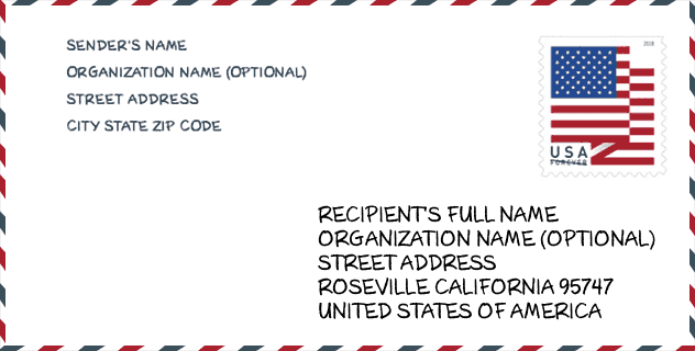
Envelope Example

This is an example of a US zip envelope. You can use a 5-digit zipcode or a detailed 9-digit zipcode to copy the mail in the following address format.
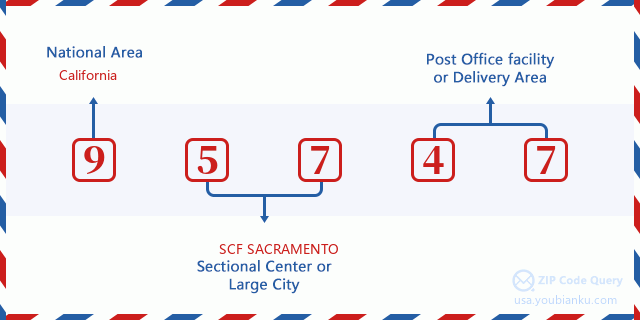
95747 Basic Meaning
What does each digit of ZIP Code 95747 stands for? The first digit designates a national area, which ranges from zero for the Northeast to nine for the far West. The 2-3 digits are the code of a sectional center facility in that region. The last two digits designate small post offices or postal zones.
Online Map

This is online map of the address Roseville, California, United States. You may use button to move and zoom in / out. The map information is for reference only.
Museum

This is the ZIP Code 95747 - Museum page list. Its detail Museum Name, Street, City, State, ZIP Code, Phone is as below.
- Name: ELVERTA HISTORICAL SOCIETY
- Street: RT 1 NOX 1545
- City: ROSEVILLE
- State: CA
- ZIP Code: 95747
- Phone: (916) 991-0338
Library

This is the ZIP Code 95747 - Library page list. Its detail Library Name, Address, City, State, ZIP Code, Phone is as below.
- Name: MARTHA RILEY COMMUNITY LIBRARY
- Address: 1501 PLEASANT GROVE BLVD
- City: ROSEVILLE
- State: CA - California
- ZIP Code: 95747
- Phone: (916) 774-5221
School

This is the ZIP Code 95747 - School page list. Its detail School Name, Address, City, State, ZIP Code is as below.
| School Name | Address | City | State | Grades | ZIP Code |
|---|---|---|---|---|---|
| Orchard Ranch Elementary | 4375 Brookstone Dr. | Roseville | CA | UG | 95747 |
| Riego Creek Elementary | 3255 Pruett Dr. | Roseville | CA | UG | 95747 |
| West Park High | 2401 PANTHER PL. | Roseville | CA | UG | 95747 |
Population for ZIP Code 95747

What is the total population in ZIP Code 95747? Below is detail information.
- Population for ZIP Code 95747: 73,949
- 2010 Population: 51,870
The 2020 demographic statistics are in progress. The current population in ZIP code 95747 is 73,949, and the population in 2010 is 51,870.
Gender

In all the statistical population, the male population is 24,765, the female population is 27,105.
- Male Population: 24,765
- Female Population: 27,105
Race

In all the statistical population, the male population is 24,765, the female population is 27,105.
- White Population: 42,769
- Black Population: 1,698
- Hispanic Population: 6,021
- Asian Population: 6,908
- Hawaiian Population: 403
- Indian Population: 796
- Other Population: 2,232
Age

In all the statistical population, the White population is 42,769, the Black population is 1,698, the Hispanic population is 6,021, the Asian population is 6,908, the Hawaiian population is 403, the Indian Ppopulation is 796 and Other population is 2,232.
- Age's Median: 37.8
- Median of male age: 36.6
- Median of female age: 38.7
Households for ZIP Code 95747
ZIP code 95747 has 18,890 households, with an average number of 2.74 persons per household. The average income per household in Zip code 95747 is 103,895 USD, and the average house value is 448,400 USD.
- Households Per Zipcode: 18,890
- Persons Per Household: 2.74
- Average House Value: 448,400
- Income Per Household: 103,895
Housing Unit

In ZIP code 95747, the growth rank of housing unit is 91, the number of housing unit was 348,432 in 2010 and increased to 357,138 in 2011, the growth increase number is 8,706, the growth increase percentage is 2.5%.
- Growth Rank: 91
- Housing Units Estimate in 2010: 348,432
- Housing Units Estimate in 2011: 357,138
- Growth Increase Number: 8,706
- Growth Increase Percentage: 2.5%
Geographic

The latitude of the Zip code 95747 is 38.784542, the longitude is -121.373449, and the elevation is 102. It has land area of 46.737 square miles, and water area of 0 square miles. The time zone for ZIP code 95747 is Pacific (GMT -08:00). Daylight saving time should be observed in the area where the zip code is located.
- Latitude: 38.784542
- Longitude: -121.373449
- Elevation: 102
- Land Area: 46.737
- Water Area: 0
- Time Zone: Pacific (GMT -08:00)
- Region: West
- Division: Pacific
- Day Light Saving: Y
Congressional District

The Congressional District for ZIP code 95747 is California's 04th congressional district, the Congressional Land Area is 12836.2 square mile.
- Congressional District: 04th
- Congressional Land Area: 12836.2
Delivery

In the ZIP code 95747, there are 26,989 residential delivery mailboxes and centralized units, and 452 commercial delivery mailbox and centralized units, 771 single family deliveries and 2,623 multifamily deliveries, and the box count is 30,230. The main post office has city delivery carrier routes for the ZIP code 95747.
- Delivery Residential: 26,989
- Delivery Business: 452
- Delivery Total: 30,230
- Single Family Delivery Units: 771
- Multi Family Delivery Units: 2,623
- City Delivery Indicator: Y
Business

In ZIP code 95747, the number of business is 794, the number of employee is 10,242, the business first quarter payroll is 120,843,000 USD, the business annual payroll is 504,841,000 USD.
- Number Of Businesses: 794
- Number Of Employees: 10,242
- Business First Quarter Payroll: 120,843,000
- Business Annual Payroll: 504,841,000
Social Security Benefits

There are 13,545 beneficiaries with benefits in current-payment status for ZIP code 95747, of which 10,745 are retired workers, 985 are disabled workers, 700 are widow(er)s and parents, 510 are spouses and 605 are children. The number of beneficiaries aged 65 or older is 11,390. The total monthly benefits are 20,886,000 USD, of which 17,348,000 USD for retired workers, 1,075,000 USD for widow(er)s and parents.
- Total Number: 13,545
- Retired workers Number: 10,745
- Disabled workers Number: 985
- Widow(er)s and parents Number: 700
- Spouses Number: 510
- Children Number: 605
- All beneficiaries per month: 20,886,000
- Retired workers per month: 17,348,000
- Widow(er)s and parents per month: 1,075,000
- Number of beneficiaries aged 65 or older: 11,390


Add new comment