ZIP Code: 28546, Jacksonville, NC
ZIP Code 28546 is located in Jacksonville, North Carolina. Its detail State, County, City, Longitude, Latitude, Envelope Example, Population is as below.
ZIP Code 28546 Information

-
-
Country:
U.S. - United States
State:
County FIPS:
37133
County:
City:
Area Code:
City Type ?In many cases, a ZIP Code can have multiple "names", meaning cities, towns, or subdivisions, in its boundaries. However, it will ALWAYS have exactly 1 "default" name. D - Default - This is the "preferred" name - by the USPS - for a city. Each ZIP Code has one - and only one - "default" name. In most cases, this is what people who live in that area call the city as well. A - Acceptable - This name can be used for mailing purposes. Often times alternative names are large neighborhoods or sections of the city/town. In some cases a ZIP Code may have several "acceptable" names which is used to group towns under one ZIP Code. N - Not Acceptable - A "not acceptable" name is, in many cases, a nickname that residents give that location. According to the USPS, you should NOT send mail to that ZIP Code using the "not acceptable" name when mailing.:
D (Default)
ZIP Code:
28546
❓What does D (Default) mean? This is the "preferred" name - by the USPS - for a city. Each ZIP Code has one - and only one - "default" name. In most cases, this is what people who live in that area call the city as well.
ZIP Code 28546 Plus 4
ZIP Code 5 plus 4 is the extension of 5-digit zip code, It can be used to locate a more detailed location. The last four digits designate segment or one side of a street or an apartment. You can find the ZIP+4 code and corresponding address of the zip code 28546 below.
| ZIP Code 5 Plus 4 | Address |
|---|---|
| 28546-0700 | PO BOX 12706, JACKSONVILLE, NC |
| 28546-0701 | PO BOX 12743, JACKSONVILLE, NC |
| 28546-0707 | PO BOX 12757, JACKSONVILLE, NC |
| 28546-0709 | PO BOX 12763, JACKSONVILLE, NC |
| 28546-1600 | 1200 GREENWAY CT, JACKSONVILLE, NC |
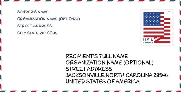
Envelope Example

This is an example of a US zip envelope. You can use a 5-digit zipcode or a detailed 9-digit zipcode to copy the mail in the following address format.
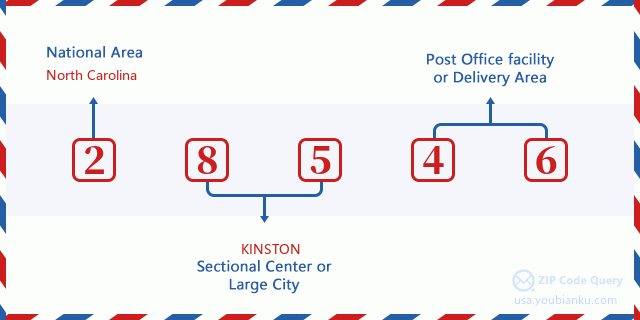
28546 Basic Meaning
What does each digit of ZIP Code 28546 stands for? The first digit designates a national area, which ranges from zero for the Northeast to nine for the far West. The 2-3 digits are the code of a sectional center facility in that region. The last two digits designate small post offices or postal zones.
Online Map

This is online map of the address Jacksonville, North Carolina, United States. You may use button to move and zoom in / out. The map information is for reference only.
University

This is the ZIP Code 28546 - University page list. Its detail university Name, Street, City, State, ZIP Code, Phone is as below.
| Name | Street | City | State | ZIP Code | Phone |
| Platt College-Miller-Motte-Jacksonville | 105 New Frontier Way | Jacksonville | NC | 28546 | (910) 478-4300 |
| Miller-Motte College-Jacksonville | 105 New Frontier Way | Jacksonville | NC | 28546 | (910) 478-4300 |
Museum

This is the ZIP Code 28546 - Museum page list. Its detail Museum Name, Street, City, State, ZIP Code, Phone is as below.
- Name: CYPRUS MUSEUM
- Street: 250 MEMORIAL DR
- City: JACKSONVILLE
- State: NC
- ZIP Code: 28546
- Phone: (910) 378-4974
School
This is the ZIP Code 28546 - School page list. Its detail School Name, Address, City, State, ZIP Code is as below.
| School Name | Address | City | State | Grades | ZIP Code |
|---|---|---|---|---|---|
| Jacksonville Commons Elem | 1121 Commons Drive North | Jacksonville | NC | UG | 28546 |
| Hunters Creek Elementary | 3450 Hunters Trail | Jacksonville | NC | UG | 28546 |
| Jacksonville Commons Middle | 315 Commons Drive South | Jacksonville | NC | UG | 28546 |
| Northside High | 365 Commons Drive South | Jacksonville | NC | UG | 28546 |
| Carolina Forest Elementary | 141 Carolina Forest Boulevard | Jacksonville | NC | UG | 28546 |
| Stateside Elementary | 132 Stateside Blvd | Jacksonville | NC | UG | 28546 |
| Onslow Early College | 444 Western Blvd | Jacksonville | NC | UG | 28546 |
Population for ZIP Code 28546

What is the total population in ZIP Code 28546? Below is detail information.
- Population for ZIP Code 28546: 53,403
- 2010 Population: 42,696
The 2020 demographic statistics are in progress. The current population in ZIP code 28546 is 53,403, and the population in 2010 is 42,696.
Gender

In all the statistical population, the male population is 20,732, the female population is 21,964.
- Male Population: 20,732
- Female Population: 21,964
Race

In all the statistical population, the male population is 20,732, the female population is 21,964.
- White Population: 29,182
- Black Population: 10,778
- Hispanic Population: 5,133
- Asian Population: 2,138
- Hawaiian Population: 305
- Indian Population: 701
- Other Population: 2,215
Age

In all the statistical population, the White population is 29,182, the Black population is 10,778, the Hispanic population is 5,133, the Asian population is 2,138, the Hawaiian population is 305, the Indian Ppopulation is 701 and Other population is 2,215.
- Age's Median: 26.4
- Median of male age: 25.5
- Median of female age: 27.5
Households for ZIP Code 28546
ZIP code 28546 has 16,153 households, with an average number of 2.62 persons per household. The average income per household in Zip code 28546 is 46,758 USD, and the average house value is 156,300 USD.
- Households Per Zipcode: 16,153
- Persons Per Household: 2.62
- Average House Value: 156,300
- Income Per Household: 46,758
Geographic

The latitude of the Zip code 28546 is 34.817584, the longitude is -77.375096, and the elevation is 43. It has land area of 56.077 square miles, and water area of 0.11 square miles. The time zone for ZIP code 28546 is Eastern (GMT -05:00). Daylight saving time should be observed in the area where the zip code is located.
- Latitude: 34.817584
- Longitude: -77.375096
- Elevation: 43
- Land Area: 56.077
- Water Area: 0.11
- Time Zone: Eastern (GMT -05:00)
- Region: South
- Division: South Atlantic
- Day Light Saving: Y
Congressional District

The Congressional District for ZIP code 28546 is North Carolina's 3rd congressional district, the Congressional Land Area is 7810.08 square mile.
- Congressional District: 3rd
- Congressional Land Area: 7810.08
Delivery

In the ZIP code 28546, there are 20,383 residential delivery mailboxes and centralized units, and 1,285 commercial delivery mailbox and centralized units, 13,422 single family deliveries and 4,133 multifamily deliveries, and the box count is 21,871. The main post office has city delivery carrier routes for the ZIP code 28546.
- Delivery Residential: 20,383
- Delivery Business: 1,285
- Delivery Total: 21,871
- Single Family Delivery Units: 13,422
- Multi Family Delivery Units: 4,133
- City Delivery Indicator: Y
Business

In ZIP code 28546, the number of business is 938, the number of employee is 16,512, the business first quarter payroll is 121,273,000 USD, the business annual payroll is 497,800,000 USD.
- Number Of Businesses: 938
- Number Of Employees: 16,512
- Business First Quarter Payroll: 121,273,000
- Business Annual Payroll: 497,800,000
Social Security Benefits

There are 7,070 beneficiaries with benefits in current-payment status for ZIP code 28546, of which 4,225 are retired workers, 1,385 are disabled workers, 455 are widow(er)s and parents, 215 are spouses and 790 are children. The number of beneficiaries aged 65 or older is 4,400. The total monthly benefits are 8,537,000 USD, of which 5,623,000 USD for retired workers, 577,000 USD for widow(er)s and parents.
- Total Number: 7,070
- Retired workers Number: 4,225
- Disabled workers Number: 1,385
- Widow(er)s and parents Number: 455
- Spouses Number: 215
- Children Number: 790
- All beneficiaries per month: 8,537,000
- Retired workers per month: 5,623,000
- Widow(er)s and parents per month: 577,000
- Number of beneficiaries aged 65 or older: 4,400


Add new comment